Antique Maps of Africa
Africa Iuxta Navigationes et Observationes Recentissimas Aucta Correcta et in sua Regna et Status Divisa, in Lucem Edita.

SEUTTER, Matthaeus.
Origin: Augsburg, 1735.
Condition: Original wash colour with some recent addition to the title cartouche; light age-toning and soiling to the margins, otherwise fine condition.
Size: 490 x 565mm (19¼ x 22¼ inches).
Reference: 12579
Price: £850
Africa, from the best Authorities.
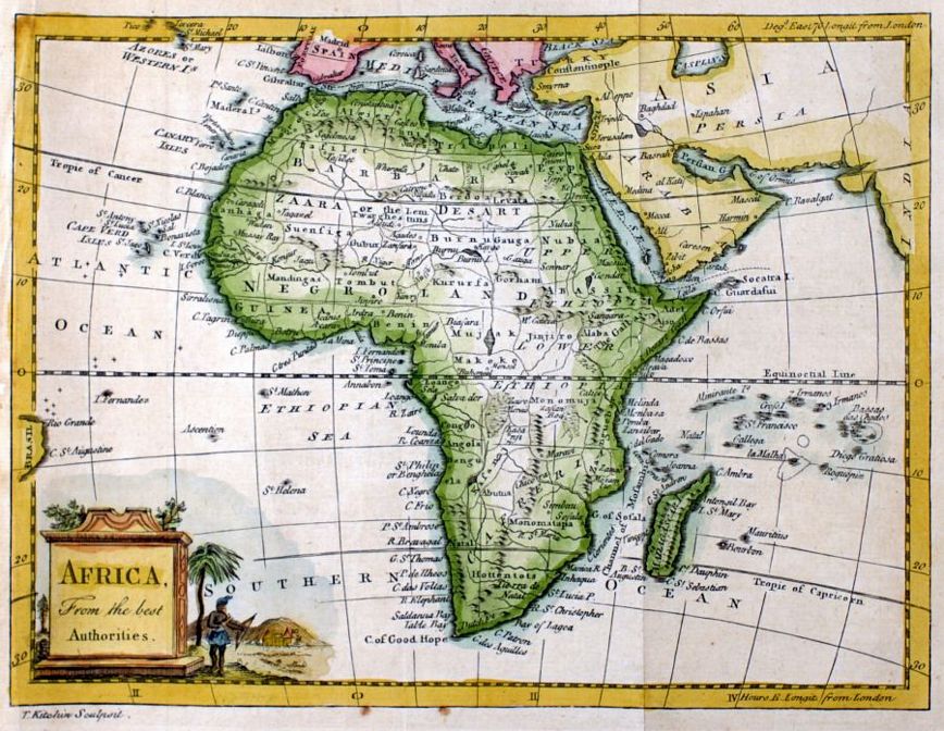
KITCHIN, Thomas.
Origin: London, c.1780.
Condition: Coloured; signs of old vertical folds from book, light marginal spotting, left margin frayed from binding close to left hand printed border, otherwise a very good example.
Size: 180 x 247mm (7 x 9¾ inches).
Reference: 12572
Price: £210
Africa.

TALLIS, John.
Origin: London, John Tallis & Company, 1851.
Condition: Original outline colour; light marginal age-toning, otherwise a fine unfolded example.
Size: 250 x 325mm (9¾ x 12¾ inches).
Reference: 8089
Price: £220
Africae Tabula Nova.

ORTELIUS, Abraham.
Origin: Antwerp, 1570-, Latin text edition.
Condition: Original colour; light soiling to margins, very short split to the lower margin at centrefold, otherwise a superb example.
Size: 375 x 505mm (14¾ x 20 inches).
Reference: 15714
Price: £1700
Afrique.
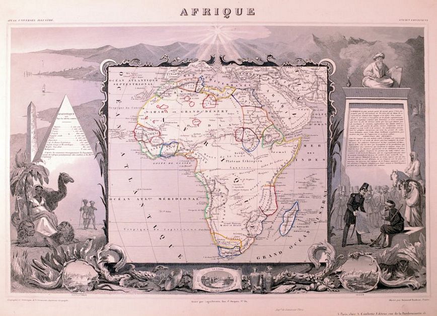
LEVASSEUR, Victor.
Origin: Paris, c.1845.
Condition: Original outline colour, with recent embellishment to the surrounding vignettes; paper lightly age-toned, minor spotting and soiling to the margins, otherwise a very good example.
Size: 315 x 440mm (12½ x 17¼ inches).
Reference: 11540
Price: £115
Afrique.

LEVASSEUR, Victor.
Origin: Paris, 1856.
Condition: Original colour; light age-toning to the edges of the margins, overall fine condition.
Size: 315 x 450mm (12½ x 17¾ inches).
Reference: 15477
Price: £110
Charte von Africa.

GÜSSEFELD, Franz Ludwig.
Origin: [Weimar, 1806.].
Condition: Original outline colour; minor spotting to the margins and light age toning, otherwise fine condition.
Size: 465 x 525mm (18¼ x 20¾ inches).
Reference: 12584
Price: £580
Im Fluge durch die Welt (Flying through the World).

ANON.
Origin: Germany, 1900.
Condition: Chromolithograph; a used postcard, with contemporary ink manuscript front and verso, postmarked "03", light age-toning.
Size: 140 x 88mm (5½ x 3½ inches).
Reference: 15680
Price: £24
L'Africa. Nuovamente corretta et accresciuta secondo le relationi piu moderne da Guglielmo Sansone.

ROSSI, Giacomo.
Origin: Rome, 1677.
Condition: Original outline colour; some light spotting and age-toning, mostly to the margins, otherwise a fine example.
Size: 400 x 550mm (15¾ x 21¾ inches).
Reference: 12578
Price: £750
L'Afrique Dressez sur les dernieres Relations par N.de Fer.

FER, Nicholas de.
Origin: Paris, 1705.
Condition: Uncoloured; signs of old folds from a much smaller book, some light age-toning to the edges of the paper. otherwise fine condition.
Size: 210 x 275mm (8¼ x 10¾ inches).
Reference: 8305
Price: £210
L'Afrique...

VAUGONDY, G. Robert de.
Origin: Paris, 1756.
Condition: Original outline colour; some very light colour offset, light soiling and staining to the margins at the edge of the paper, otherwise a fine example.
Size: 465 x 590mm (18¼ x 23¼ inches).
Reference: 12583
Price: £480
Presbiteri Iohannis, si:ve, Abissino:rum Imperii descriptio.

ORTELIUS, Abraham.
Origin: Antwerp, 1598, French text edition.
Condition: Finely coloured; some worming to the margins, particularly noticeable in the upper margin when held up to the light, all expertly repaired and these will be covered in matting and framing. Otherwise overall good paper and in very good condition.
Size: 370 x 440mm (14½ x 17¼ inches).
Reference: 15707
Price: £920
