Antique Maps of Scandinavia
Norway, Sweden, Finland, Denmark, Iceland

Copenhagen.

image

Society for the Diffusion of Useful Knowledge. (S.D.U.K.)

Origin: London, Baldwin & Cradock, 1837.

An early Victorian detailed plan of the city, drawn br W.B.Clarke and engraved by J.Henshall, with a prospect of the city below. From the 1844 edition published by Chapman & Hall, for The Society for the Diffusion of Useful Knowledge. With a prospect of the city under the map.

Condition: Original outline colour; light age-toning to the edges of the margins, minor light staining, otherwise a very good example.

Size: 330 x 395mm (13 x 15½ inches).

Reference: 10657

Price: £110

[this is simply us checking that you are a human!]

Das Koenigreich Schweden und Norwegen.

image

SCHREIBER, Johann Georg.

Origin: Leipzig, c.1730.

Published in Schriber's Atlas Selectus. The whole of Scandinavia.

Condition: Original colour.

Size: 165 x 240mm (6½ x 9½ inches).

Reference: 6007

Price: £140

[this is simply us checking that you are a human!]

Denmark.

image

TALLIS, John.

Origin: London, John Tallis & Co., 1851.

With engraved vignettes including views of Copenhagen and Sleswig. John Tallis is without question one of the most renowned cartographers and publisher of the C19th. His maps are the last of the lavishly decorated and ornamental maps, considered to be works of art as well as geographically accurate. He was born in Stourbridge in Worcestershire in about 1818 and it is likely that he stayed in the Midlands working as a publisher in Birmingham, until he moved to London in the early 1840′s.

Condition: Original outline colour; minor spotting to engraved border, otherwise overall good to fine condition.

Size: 330 x 250mm (13 x 9¾ inches).

Reference: 7772

Price: £48

[this is simply us checking that you are a human!]

Islanda.

image

PORCACCHI, Tomaso.

Origin: Venice, 1572-1605.

A fine early map of Iceland published in 'L'Isole del Monde'. Set in a page of text from a separate copper plate.

Condition: Uncoloured; overall good condition, with minor spotting and soiling to text area and margins.

Size: 105 x 145mm (4¼ x 5¾ inches).

Reference: 9943

Price: £260

[this is simply us checking that you are a human!]

La Gran Penisola Della Scandia.

image

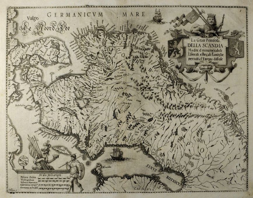
DE PIENE, Antonio (engraver).

Origin: Turin, 1664.

A scarce map of the whole of Scandinavia, with decorative cartouche. North is orientated to the right. Engraved by Antonio de Piene (not in Tooley Dictionary of Mapmakers) for "Emmanuele Tesauro's Del Regno d'Italia Sotto i Barbari Epitome".

Condition: Slight darkening of centrefold otherwise good.

Size: 280 x 360mm (11 x 14¼ inches).

Reference: 6012

Price: £280

[this is simply us checking that you are a human!]

Septentrio:nalium Reg:ionvm Svet:iæ, Gothiæ, Norvegiæ, Daniæ &.

image

QUAD, Matthias.

Origin: Cologne, John Bussemacher, 1592-1620.

An early map of Scandinavia, shows Norway, Sweden and Denmark.

Condition: Uncoloured; very light age-toning of paper and minor marginal staining, otherwise very good condition.

Size: 220 x 305mm (8¾ x 12 inches).

Reference: 10897

Price: £340

[this is simply us checking that you are a human!]

Stockholm.

image

S.D.U.K.

Origin: London, Baldwin & Craddock, 1836.

An early Victorian detailed plan of the city, with a finely engraved inset panorama below. From the 1844 edition published by Chapman & Hall for The Society for the Diffusion of Useful Knowledge, with a finely engraved inset panorama.

Condition: Original outline colour; very light age-toning to the edges of the margins, slight soiling to the right-hand margin, trimmed close at the top edge without loss of print, otherwise a very good example.

Size: 335 x 400mm (13¼ x 15¾ inches).

Reference: 16112

Price: £110

[this is simply us checking that you are a human!]

Sweden and Norway.

image

TALLIS, John.

Origin: London, J & F Tallis, 1851.

A fine map of Scandiavia with engraved vignettes including; a view of Norwegian Skielobere or Skate Runners (ski-ing), Peasants of Norway and of Sweden, also Laplanders in winter dress; an iron mine and a prospect of Stockholm. John Tallis is without question one of the most renowned cartographers and publisher of the C19th. His maps are the last of the lavishly decorated and ornamental maps, considered to be works of art as well as geographically accurate. He was born in Stourbridge in Worcestershire in about 1818 and it is likely that he stayed in the Midlands working as a publisher in Birmingham, until he moved to London in the early 1840′s.

Condition: Original outline colour; light spotting and age-toning to the edges of the paper, overall a fine example.

Size: 340 x 240mm (13½ x 9½ inches).

Reference: 7450

Price: £170

[this is simply us checking that you are a human!]

Synopsis Plagæ Septentrionalis sive Sueciæ Daniæ et Norwegiæ Regn.

image

SEUTTER, Matthaeus.

Origin: Augsburg, c.1740.

Highly decorative map of Scandinavia and the Baltic states with a finely-engraved allegorical title cartouche top left.

Condition: Fine original wash colour; short centrefold split (repaired), minor marginal soiling, otherwise a fine example.

Size: 490 x 570mm (19¼ x 22½ inches).

Reference: 4450

Price: £580

[this is simply us checking that you are a human!]