Antique Maps of North America & Canada
(Sketch Map) Dominion of Canada. Albert Railway of New Brunswick.

ANON.
Origin: Unknown publication date or place.
Condition: Coloured lithograph: signs of old folds, light soiling, otherwise good condition.
Size: 430 x 520mm (17 x 20½ inches).
Reference: 9316
Price: £45
A Plan of the City & Harbour of Louisburg.

KITCHIN, Thomas..
Origin: London Magazine, 1745 - c.1780
Condition: Uncoloured; light age-toning to the edges of the margins, otherwise a very good example.
Size: 195 x 110mm (7¾ x 4¼ inches).
Reference: 9488
Price: £55
Alaska.
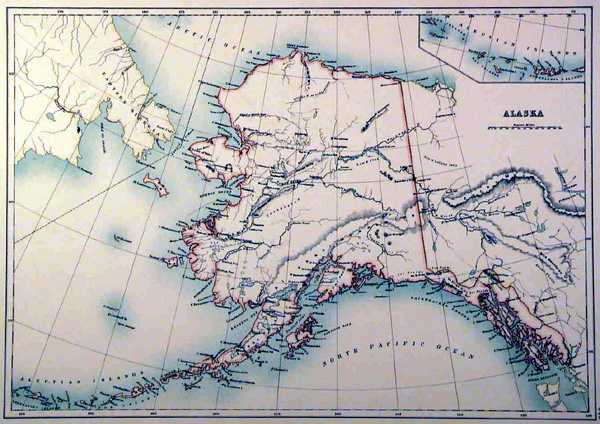
ANON.
Origin: [London, c.1880].
Condition: Original coloured lithograph; fine condition.
Size: 275 x 395mm (10¾ x 15½ inches).
Reference: 12279
Price: £23
Boston with Charleston and Roxbury.
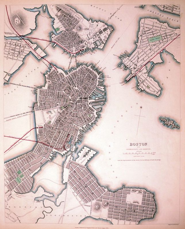
Society for the Diffusion of Useful Knowledge. (S.D.U.K.)
Origin: London, Chapman & Hall, 1842.
Condition: Original outline colour; very light age-toning to the edges of the margins, some minor soiling, otherwise a very good example.
Size: 365 x 300mm (14¼ x 11¾ inches).
Reference: 10663
Price: £120
Boston.

TALLIS, John.
Origin: London, John Tallis & Company, 1851.
Condition: Uncoloured; very minor marginal age-toning, trimmed by binder close to title at the top, with no loss of printed surface, otherwise a fine unfolded example.
Size: 260 x 325mm (10¼ x 12¾ inches).
Reference: 11154
Price: £150
British America.

TALLIS, John.
Origin: London, John Tallis & Company, 1851.
Condition: Original outline colour; trimmed at bottom edge just catching publishers imprint, very minor marginal age-toning, otherwise a fine unfolded example.
Size: 270 x 330mm (10¾ x 13 inches).
Reference: 7466
Price: £150
Chart of Norton Sound and of Bherings Strait made by the East Cape of Asia and the West Point of America.

HOGG, Alexander.
Origin: London, c.1795.
Condition: Uncoloured; minor age-toning to margins, otherwise good condition.
Size: 210 x 330mm (8¼ x 13 inches).
Reference: 8286
Price: £48
Der Noerdlichetheil des Grossenwelt Meeres...…

WEIMAR, GEOGRAPHISCHES INSTITUT.
Origin: Weimar, 1826.
Condition: Original outline colour; fine condition.
Size: 520 x 680mm (20½ x 26¾ inches).
Reference: 7881
Price: £290
East Canada and New Brunswick.

TALLIS, John.
Origin: London, John Tallis & Co.1851.
Condition: Original outline colour; very minor spotting and marginal soiling, otherwise a fine unfolded example.
Size: 255 x 335mm (10 x 13¼ inches).
Reference: 7443
Price: £58
Kaart van het Westelyk Gedeelte van Nieuw Mexico en van California.

TIRION, Isaak.
Origin: Amsterdam, 1765.
Condition: Original colour; fine condition with no faults.
Size: 325 x 350mm (12¾ x 13¾ inches).
Reference: 7329
Price: £480
Map of the Eastern portion of British North America including the Gulf of St. Lawrence, and part of the New England States compiled from the latest Surveys abd Charts, by Henry F. Perley for the report of Israel D. Andrews'.

ANDREWS, Israel D.
Origin: New York, Ackerman, 1853.
Condition: Original hand coloured lithograph; splits at folds and intersections, laid on fine linen as published, one or two small brown spots, small folds at the edges of the sheet, two large sheets conjoined, overall good apart from the listed faults.
Size: 660 x 1170mm (26 x 46 inches).
Reference: 15686
Price: £180
Map of the South-Western Portion of the United States and of Sonora and Chihuahua to illustrate the paper by Dr W. A. Bell.

RAVENSTEIN, E.G.
Origin: London, 1870.
Condition: Original coloured lithograph; very light age-toning, otherwise a fine example.
Size: 225 x 370mm (8¾ x 14½ inches).
Reference: 10800
Price: £45
Map of the Straits of Florida and Gulf of Mexico. To accompany a report from the Treasury Department by Israel D. Andrews in obedience to the resolution of the Senate of March 8th, 1851
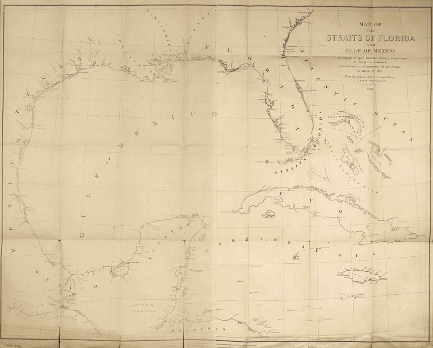
ANDREWS, Israel DeWolf.
Origin: Washington, U.S. Coast Survey, 1852.
Condition: Lithograph; two sheet conjoined, the left sheet showing light age-toning, splits at folds and intersections, short tears to the edges of the paper, packed with the original fine linen, overall a fair example.
Size: 680 x 865mm (26¾ x 34 inches).
Reference: 15687
Price: £260
Mexico, California, Texas &c.

TALLIS, John.
Origin: London, London Printing & Publishing Co., 1851.
Condition: Original outline colour; very minor marginal soiling, otherwise a fine unfolded example.
Size: 260 x 330mm (10¼ x 13 inches).
Reference: 7471
Price: £260
Newfoundland & Nova Scotia.

TALLIS, John.
Origin: London, John Tallis & Company, 1851.
Condition: Original outline colour; trimmed close at upper edge close to scrolling of title, slight marginal age-toning, otherwise a fine example.
Size: 260 x 330mm (10¼ x 13 inches).
Reference: 7505
Price: £58
North America.
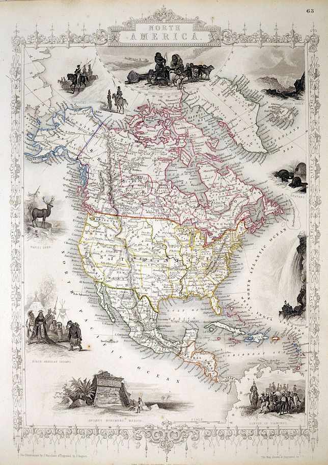
TALLIS, John.
Origin: London, John Tallis & Co., c.1851.
Condition: Original outline colour; short repaired tear to right-hand margin just effecting the decorative border, hardly noticable, otherwise a fine unfolded example.
Size: 350 x 240mm (13¾ x 9½ inches).
Reference: 7490
Price: £210
North America.

TALLIS, John.
Origin: London, The London Printing & Publishing Co.1851.
Condition: Original outline colour; short repaired tear to left-hand margin just effecting the decorative border and the Wafiti Deer vignette, hardly noticable, otherwise a fine unfolded example.
Size: 350 x 240mm (13¾ x 9½ inches).
Reference: 8133
Price: £190
Nova Scotia & Newfoundland.

TALLIS, John.
Origin: London, John Tallis & Company, 1851.
Condition: Original outline colour; very light age-toning to the edges, otherwise overall fine condition.
Size: 265 x 330mm (10½ x 13 inches).
Reference: 7465
Price: £78
Philadelphia.

Society for the Diffusion of Useful Knowledge, (S.D.U.K.)
Origin: London, SDUK, 1840.
Condition: Uncoloured; light age-toning to the edges of the margins, minor spotting and very light soiling, otherwise a very good example.
Size: 380 x 300mm (15 x 11¾ inches).
Reference: 10694
Price: £78
United States.

TALLIS, John.
Origin: London, John Tallis & Co., 1851.
Condition: Original outline colour; slight age-toning to top edge, otherwise a fine unfolded example.
Size: 250 x 345mm (9¾ x 13½ inches).
Reference: 7489
Price: £230
Virginiæ partis australis et Floridæ partis orientalis, interjacentiumq. regionum Nova Descriptio.

BLAEU, Willem.
Origin: Amsterdam, 1642. German text edition.
Condition: Coloured; light marginal soiling, otherwise a fine example.
Size: 385 x 505mm (15¼ x 20 inches).
Reference: 10863
Price: £1100
West Canada.

TALLIS, John.
Origin: London, John Tallis & Company, 1851.
Condition: Original outline colour; very light age-toning to the edges of the paper, otherwise a fine unfolded example.
Size: 255 x 320mm (10 x 12½ inches).
Reference: 7451
Price: £110
