Antique Maps of Europe

A New Mappe of the Roman Empire newly described by John Speede.

image

SPEED, John.

Origin: London, Bassett & Chiswell, 1627-76.

Despite the title, this map has six bird's-eye views of cities (Rome, Genoa, Jerusalem, Venice, Constantinople & Alexandria), and ten costume vignettes, all 17th century, not Roman era. In the sea off Ireland is a sea-battle, again with galleons rather than galleys. Engraved by Abraham Goos for Speed's Prospect of the World, with a two-page English text "The Description of Roman Empire" on verso.

Condition: Uncoloured; very light marginal age-toning, tiny centrefold split at lower margin, otherwise a sperb example of the 1676 edition on thicker paper; a dark impression.

Size: 395 x 515mm (15½ x 20¼ inches).

Reference: 10264

Price: £1550

[this is simply us checking that you are a human!]

A New and Accurate Map of Europe.

image

BOWEN, Emanuel.

Origin: London, 1748.

A map of Europe with a decorative title cartouche, shows an 'Old Father Thames' type figure reclining with an overturned barrel, often used to prtray the source of a river. Issued in John Harris's 'Navigantium atque Itinerantium Bibliotheca', or 'A Complete Collection of Voyages and Travels'.

Condition: Uncoloured; light age-toning, signs of old vertical folds from book, otherwise fine.

Size: 370 x 450mm (14½ x 17¾ inches).

Reference: 9388

Price: £280

[this is simply us checking that you are a human!]

Carta Nuova dell Europa secondo le ultime ofservazioni fatta in Amsterdam appresso Isaa. Tirion.

image

TIRION, Isaac.

Origin: Venice, Girolamo Albrizzi, 1740.

A map of Europe from 'Atlante Novissimo che Contiene Tutte le Parti del Mondo'.

Condition: Uncoloured; light centrefold toning due to guard paste, very light print offset and minor marginal staining, otherwise a fine example.

Size: 280 x 340mm (11 x 13½ inches).

Reference: 9748

Price: £180

[this is simply us checking that you are a human!]

Europa.

image

QUAD, Matthias.

Origin: Cologne, Johan Bussemacher, 1600.

A fine map of Europe, similar in style to that of Ortelius and retaining the mythical Atlantic islands of Brasil and Demar.

Condition: Uncoloured; slight marginal water staining, otherwise very good.

Size: 195 x 260mm (7¾ x 10¼ inches).

Reference: 6992

Price: £360

[this is simply us checking that you are a human!]

Europa.

image

QUAD, Matthias.

Origin: Cologne, John Bussemacher, 1592-1600.

A finely engraved map of Europe, unlike others in the atlas there is no attribution on this map, however it is possibly engraved by Matthias Quad.

Condition: Uncoloured; very light age-toning of paper and other marginal staining, and nicks, otherwise good condition.

Size: 195 x 265mm (7¾ x 10½ inches).

Reference: 8982

Price: £280

[this is simply us checking that you are a human!]

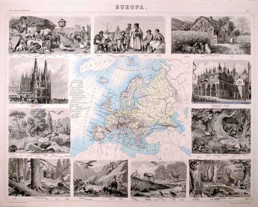
Europa.

image

BROCKHAUS, F. A.

Origin: Leipzig, 1863.

A finely engraved map of Europe, surrounded by decorative vignettes.

Condition: Original coloured lithograph: light age-toning and minor staining to margins, otherwise a good example.

Size: 360 x 460mm (14¼ x 18 inches).

Reference: 10893

Price: £90

[this is simply us checking that you are a human!]

Europe

image

LEVASSEUR, Victor.

Origin: Paris, c.1845.

Steel engraving, with finely engraved vignette borders with allegorical figures, etc.

Condition: Original outline colour; steel engraving, fine condition.

Size: 330 x 460mm (13 x 18 inches).

Reference: 8841

Price: £95

[this is simply us checking that you are a human!]

Europe

image

LEVASSEUR, Victor.

Origin: Paris, 1856.

A steel engraving, with finely engraved vignette borders with allegorical figures, etc.

Condition: Original outline colour; light age-toning to margins and minor soiling, otherwise a fine example.

Size: 330 x 460mm (13 x 18 inches).

Reference: 11893

Price: £90

[this is simply us checking that you are a human!]

Europe.

image

TALLIS, John.

Origin: London, John Tallis & Co., 1851.

With vignettes of seal-hunting, a sledge and a slavemarket. John Tallis is without question one of the most renowned cartographers and publisher of the C19th. His maps are the last of the lavishly decorated and ornamental maps, considered to be works of art as well as geographically accurate. He was born in Stourbridge in Worcestershire in about 1818 and it is likely that he stayed in the Midlands working as a publisher in Birmingham, until he moved to London in the early 1840′s.

Condition: Original outline colour; very minor spotting to margins, otherwise very good.

Size: 260 x 320mm (10¼ x 12½ inches).

Reference: 7720

Price: £75

[this is simply us checking that you are a human!]

Europe.

image

S.D.U.K.

Origin: London, Thomas Letts, 1877.

The whole of Europe and parts of Russia.

Condition: Original outline colour; superb condition.

Size: 320 x 385mm (12½ x 15¼ inches).

Reference: 8334

Price: £48

[this is simply us checking that you are a human!]

Im Fluge durch die Welt (Flying through the World).

image

ANON.

Origin: Germany, 1899.

A German postcard map of Europe, showing a stag, a village scene with windmill, statue and birds. Postmarked 1899, with stamp.

Condition: Chromolithograph; a used postcard, with contemporary ink manuscript front and verso, light age-toning.

Size: 140 x 88mm (5½ x 3½ inches).

Reference: 15684

Price: £26

[this is simply us checking that you are a human!]

Imperii Caroli Magni et vicinarum regionum Descriptio dedicata et inscripta Ludovico, regi, Victori,...…

image

BLAEU, Johannes.

Origin: Amsterdam, 1650, Dutch text edition.

The Empire of Charlemagne. Extends from Ireland to Turkey and from Russia to Portugal. Legend has it that Charlemagne made a pilgrimage to Jerusalem towards the latter end of the 10th century. That he and his warriors were endowed with great deeds of earlier kings and heroes of the Frankish Kingdom, although in some cases these feats were not chronologically correct. Charlemagne's wars in Italy, Spain and Saxony formed part of the myth and also against the Slavs. The popular belief that he was the champion of Christianity against the creed of Mohammed. In 1164 he was canonized and in parts of Europe there were festivals in his honour, although I am not sure if this continues today.

Condition: Fine original colour; light age toning, old folds due to the size of the map and from being folded into a smaller volume, some minor splits at intersection of folds, two sheets conjoined, otherwise overall very good condition.

Size: 645 x 970mm (25½ x 38¼ inches).

Reference: 8552

Price: £480

[this is simply us checking that you are a human!]

L'Europe suivant les nouvelles observations.

image

FER, Nicolas de.

Origin: Paris, 1717.

A map of Europe.

Condition: Uncoloured; very light age-toning of top edge of the upper margin, old paper repaired tear to left edge due to rough treatment in the book, otherwise a good example.

Size: 225 x 335mm (8¾ x 13¼ inches).

Reference: 8861

Price: £260

[this is simply us checking that you are a human!]

Lumen Historiarum per Occidentem ex conatibus Fran Haraei Antverpiæ.

image

ORTELIUS, Abraham.

Origin: Antwerp, Fran. Hareio, 1624.

A map of the Mediterranean Sea, also covering the southern parts of the British Isles across to Crete, from the 'Parergon', the last edition of 1624.

Condition: Dark impression, uncoloured; some minor spotting and rust mark, light toning to the edges of the paper, otherwise a fine example.

Size: 273 x 355mm (10¾ x 14 inches).

Reference: 15944

Price: £340

[this is simply us checking that you are a human!]

No Title, with paste on text panel 'Les Revolutions De L'Univers;'.

image

ANON.

Origin: [Paris, c.1800].

Possibly the western section of a two sheet map; this one showing Europe, North Africa, Arabia, Middle East Southern Scandinavia and parts of Russia. With pasted on text in French and inset map of Greece and the Greek Islands, and another of the Western Hemisphere (Americas).

Condition: Original colour; some light toning to the edges of the paper, short tears to folds, otherwise a fair example.

Size: 500 x 606mm (19¾ x 23¾ inches).

Reference: 15839

Price: £240

[this is simply us checking that you are a human!]

No Title, with paste on text panel 'XVI Intervalle'.

image

ANON.

Origin: [Paris, c.1800].

One of perhaps two sheets; a map showing Europe, North Africa, Arabia, Middle East Southern Scandinavia and parts of Russia. With pasted on text in French and inset map of Greece and the Greek Islands, and another of the Western Hemisphere (Americas).

Condition: Original body colour; some light toning, otherwise very good.

Size: 500 x 606mm (19¾ x 23¾ inches).

Reference: 15840

Price: £240

[this is simply us checking that you are a human!]

Nova Europæ Descriptio.

image

DE WIT, Frederick.

Origin: Amsterdam, c.1670.

A highly decorative carte-a-figures map of the European Continent. The side borders show native figures and six town plans are diplayed across the top border, they are; Rome, Amsterdam, Paris, London, Seville and Prague.

Condition: Original colour; light soiling mainly to the margins, otherwise a fine example.

Size: 440 x 560mm (17¼ x 22 inches).

Reference: 10498

Price: £2500

[this is simply us checking that you are a human!]