Antique Maps of New Zealand
La Nouva Zelanda trascorsa nel 1769. e1770. Dal Cook Comandante dell' Endeavour.
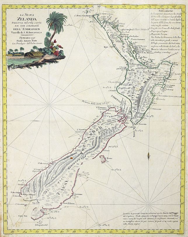
ZATTA, Antonio.
Origin: Venice, 1778.
A cornerstone map to any collection and the first published atlas map of the whole of New Zealand. Based on discoveries made on Cook's first voyage, but published shortly before his official accounts. Cook's tracks are clearly marked as well as his soundings and astronomical observations. Both the North and South Island are shown in detail, as Cook sailed off the coast for 6 months, finally proving that New Zealand was not part of the Great Southern Continent. Of great interest is Stewart Island, mapped as a peninsular, and Banks Peninsular, mapped as an island. Antonio Zatta (fl. 1757-1797) a prominent Italian cartographer, editor and publisher. From 'Atlante Novissimo'.
Condition: Original colour; very light marginal staining and spotting, light spotting in one place on the South Island, otherwise fine. This example is end bound from the book and does not have a centrefold.
Size: 445 x 360mm (17½ x 14¼ inches).
Reference: 15705
Price: £1950
The Head of a New Zealand Chief curiously tataowed [sic]

COOK, Capt. James.
Origin: London, Gentlemans' Magazine, c.1775.
An engraving of a tattooed New Zealand Chief, published in the "Gentleman's Magazine".
Condition: Uncoloured; light age-toning and soiling, otherwise fair to good.
Size: 165 x 105mm (6½ x 4¼ inches).
Reference: 15391
Price: £30
