Antique Maps of the African Islands
Carte de L'Isle de Bourbon, autrefois Mascarigne.

BELLIN, Jacques Nicholas.
Origin: Paris, c.1750.
Condition: Uncoloured; signs of old vertical fold, otherwise very good.
Size: 210 x 250mm (8¼ x 9¾ inches).
Reference: 5300
Price: £68
Carte de l'Isle de Bourbon autrefois Mascareigne.

BELLIN, Jacques Nicholas.
Origin: Paris, 1758.
Condition: Uncoloured; very slight age-toning, otherwise very good.
Size: 205 x 240mm (8 x 9½ inches).
Reference: 4195
Price: £85
Parte della Costa Orientale dell' Africa con l'Isola di Madagascar e le Carte particolari dell'Isole di Francia e di Borbon.
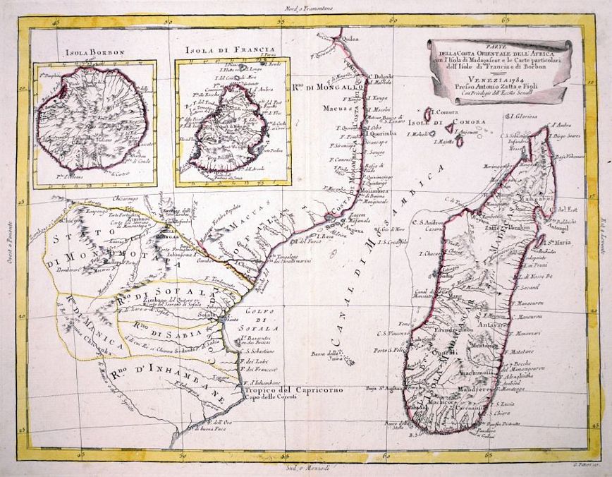
ZATTA, Antonio.
Origin: Venice, 1784.
Condition: Original colour; very light marginal staining, otherwise a fine example.
Size: 315 x 405mm (12½ x 16 inches).
Reference: 8507
Price: £210
S. Lorenzo.

PORCACCHI, Tommaso.
Origin: Venice, Alphonsus Lasor a Varea, 1713.
Condition: Uncoloured; slight overall age-toningand minor creasing to the text above and below the map.
Size: 105 x 150mm (4¼ x 6 inches).
Reference: 4215
Price: £85
Sancta Helena.

BERTIUS, Petrus.
Origin: Amsterdam, Judocus Hondius, 1616.
Condition: Uncoloured; very light overall age-toning and minor marginal staining, otherwise fine condition.
Size: 95 x 135mm (3¾ x 5¼ inches).
Reference: 9086
Price: £130
St Helena.

AA, Pieter van der.
Origin: Leiden, 1729.
Condition: Uncoloured; very light age-toning to the edges of the margins, otherwise a fine example.
Size: 250 x 320mm (9¾ x 12½ inches).
Reference: 15584
Price: £280
[No title]. St Helene.

ANON.
Origin: [Paris, c.1660.
Condition: Uncoloured; signs of old vertical folds from book, very light age-toning to the edges of the paper, otherwise a fine example.
Size: 140 x 117mm (5½ x 4½ inches).
Reference: 15593
Price: £80
