Antique Maps of South America

Amérique Méridionale.

image

MONIN, Charles, V.

Origin: Paris, c.1844.

A detailed map of South America, with each country coloured in bright original body colour.

Condition: Original body colour; light marginal spotting, two darker water stains to left margin, small tear to edge of upper and lower margin, otherwise a fine example.

Size: 645 x 455mm (25½ x 18 inches).

Reference: 12318

Price: £68

[this is simply us checking that you are a human!]

America Meridio:nalis.

image

MERCATOR, Gerard.

Origin: Amsterdam, Jodocus Hondius & Johannis CLOPPENBURG, 1632.

A map of South America. From the rare Cloppenburg edition - a larger format edition of Mercator's pocket atlas. With a page of relevant text in Latin.

Condition: Uncoloured; slight age-toning of paper, minor staining and minor defects to margins, otherwise very good.

Size: 190 x 255mm (7½ x 10 inches).

Reference: 7778

Price: £260

[this is simply us checking that you are a human!]

America Meridionalis conciñata juxta observationes...…

image

LOTTER, Tobias Conrad.

Origin: Augsburg, 1772.

A map of South America, with highly decorative figured cartouche, shows natives, a parrot, and suprisingly, an elephant. The tracks of many of the early explorers are shown, including; Le Maire and Schouten, ano. 1616, Drake, ano. 1577, Magellan, ano. 1520 and Mendaña, then Quiros, ano. 1595.

Condition: Original body colour; very minor marginal soiling and two very small holes, otherwise a fine example.

Size: 455 x 580mm (18 x 22¾ inches).

Reference: 8016

Price: £590

[this is simply us checking that you are a human!]

America Meridionalis.

image

MERCATOR, Gerard.

Origin: London, Michaell Sparke & Samuel Cartwright, 1635.

A map of South America. From the 'Historia Mundi or Marcator's Atlas'...enlarged with new mapps... by Jodocus Hondy [sic]. English text title outside platemark reads; Southerne America. Translated into English by W. Saltonstall.

Condition: Uncoloured; very slight show through of text from verso as is often the case with this edition, otherwise fine.

Size: 145 x 190mm (5¾ x 7½ inches).

Reference: 7569

Price: £210

[this is simply us checking that you are a human!]

Bowles's New One-Sheet Map of South America, divided into its Provinces, Governments, &c. and exhibiting the Spanish, Portuguese, French & Dutch settlements therein according to D'Anville, by L. Delarochette.

image

BOWLES (Carington).

Origin: London, Bowles & Carver, 1794-98.

A fine and detailed map of South America. Published in 'Bowles's Universal Atlas, Being a Complete Collection of New and Accurate Maps'.

Condition: Original body colour; very light spotting in places, slight darkening at centrefold due to guard paste, otherwise a very good example.

Size: 470 x 575mm (18½ x 22¾ inches).

Reference: 11387

Price: £380

[this is simply us checking that you are a human!]

Brasil.

image

GIBSON, John.

Origin: London, 1792.

A miniature map. From the 'Atlas Minimus', drawn and engraved by John Gibson , revised, corrected and improved by Emanuel Bowen.

Condition: Uncoloured; fine condition.

Size: 95 x 65mm (3¾ x 2½ inches).

Reference: 7522

Price: £42

[this is simply us checking that you are a human!]

Brazil.

image

TALLIS, John.

Origin: London, London Printing & Publishing Co., 1851.

With engraved vignettes including a view of Rio de Janeiro and Monte Video. John Tallis is without question one of the most renowned cartographers and publisher of the C19th. His maps are the last of the lavishly decorated and ornamental maps, considered to be works of art as well as geographically accurate. He was born in Stourbridge in Worcestershire in about 1818 and it is likely that he stayed in the Midlands working as a publisher in Birmingham, until he moved to London in the early 1840′s.

Condition: Original outline colour; very minor marginal soiling, otherwise a fine unfolded example.

Size: 350 x 240mm (13¾ x 9½ inches).

Reference: 7460

Price: £85

[this is simply us checking that you are a human!]

Brazil.

image

TALLIS, John.

Origin: London, London Printing & Publishing Co., 1851.

A map of Brazil with engraved vignettes including a view of Rio de Janeiro and Monte Video. John Tallis is without question one of the most renowned cartographers and publisher of the C19th. His maps are the last of the lavishly decorated and ornamental maps, considered to be works of art as well as geographically accurate. He was born in Stourbridge in Worcestershire in about 1818 and it is likely that he stayed in the Midlands working as a publisher in Birmingham, until he moved to London in the early 1840′s.

Condition: Original outline colour, with some recent addition colour on the vignettes; very minor marginal soiling, otherwise a fine unfolded example.

Size: 350 x 240mm (13¾ x 9½ inches).

Reference: 15719

Price: £85

[this is simply us checking that you are a human!]

British Guayana.

image

TALLIS, John.

Origin: London, John Tallis & Co., 1851.

With engraved vignettes including a view of Georgetown. John Tallis is without question one of the most renowned cartographers and publisher of the C19th. His maps are the last of the lavishly decorated and ornamental maps, considered to be works of art as well as geographically accurate. He was born in Stourbridge in Worcestershire in about 1818 and it is likely that he stayed in the Midlands working as a publisher in Birmingham, until he moved to London in the early 1840′s.

Condition: Original outline colour; slight age-toning and spotting mainly to margins otherwise good.

Size: 350 x 250mm (13¾ x 9¾ inches).

Reference: 7724

Price: £32

[this is simply us checking that you are a human!]

British Guayana.

image

TALLIS, John.

Origin: London, John Tallis & Co., 1851.

With engraved vignettes including a view of Georgetown, New Amsterdam, Christmas Cataract on the River Berbice and Ataraipu, or the Devil's Rock.

Condition: Original outline colour, with some recent embellishment to the printed border; overall a very good example.

Size: 350 x 250mm (13¾ x 9¾ inches).

Reference: 15716

Price: £36

[this is simply us checking that you are a human!]

Carta Geografica del Bresil.

image

L'ISLE, Guillaume de.

Origin: Venice, Girolamo Albrizzi, 1740.

A fine map of Brazil, with decorative figured cartouche from 'Atlante Novissimo che Contiene Tutte le Parti del Mondo'.

Condition: Uncoloured; very light centrefold toning due to guard paste, minor marginal staining, otherwise a fine example.

Size: 330 x 430mm (13 x 17 inches).

Reference: 12888

Price: £260

[this is simply us checking that you are a human!]

Carta Geografica della America Meridionale.

image

L'ISLE, Guillaume de.

Origin: Venice, Girolamo Albrizzi, 1740.

A fine map of South America with decorative figured cartouche from 'Atlante Novissimo che Contiene Tutte le Parti del Mondo'.

Condition: Uncoloured; light centrefold toning due to guard paste, very light print offset and minor marginal staining, otherwise a fine example.

Size: 330 x 430mm (13 x 17 inches).

Reference: 9732

Price: £240

[this is simply us checking that you are a human!]

Carte Générale Du Pérou, du Haut-Pérou, Du Chili et se la Plata;

image

BRUÉ, Adrien.

Origin: Paris, 1826.

A detailed map of parts of South America, showing; parts of Columbia, Peru, Bolivia, Chile, Patagonia, Argentina and Paraguay.

Condition: Original outline colour; minor spotting in margins, fine condition.

Size: 510 x 365mm (20 x 14¼ inches).

Reference: 12317

Price: £58

[this is simply us checking that you are a human!]

Carte Générale de L'Amerique Meridionale....

image

LAPIE, M.

Origin: Paris, 1829.

A steel plate engraving of the whole of South America. With a blind stamp in the sea area of Universel de Geographie (Lapie).

Condition: Original colour; overall fine condition.

Size: 530 x 390mm (20¾ x 15¼ inches).

Reference: 5251

Price: £85

[this is simply us checking that you are a human!]

Carte du Pérou.

image

TARDIEU, Ambroise.

Origin: Paris, Chez Étienne Ledoux, 1821.

A map of Peru published in 'Atlas pour servir a l'intelligence de L'Histoire Générale des Voyages, De Laharpe'.

Condition: Original outline colour; minor waterstain to one corner, light age-toning to the edges of the margins, otherwise a good example.

Size: 255 x 395mm (10 x 15½ inches).

Reference: 9804

Price: £68

[this is simply us checking that you are a human!]

Chili and La Plata.

image

TALLIS, John.

Origin: London, London Printing & Publishing Co., 1851.

With engraved vignettes including a view of the Grand Square, Buenos Ayres. John Tallis is without question one of the most renowned cartographers and publisher of the C19th. His maps are the last of the lavishly decorated and ornamental maps, considered to be works of art as well as geographically accurate. He was born in Stourbridge in Worcestershire in about 1818 and it is likely that he stayed in the Midlands working as a publisher in Birmingham, until he moved to London in the early 1840′s.

Condition: Original outline colour; minor spotting to engraved border, otherwise very good.

Size: 350 x 250mm (13¾ x 9¾ inches).

Reference: 7719

Price: £48

[this is simply us checking that you are a human!]

Falkland Islands and Patagonia.
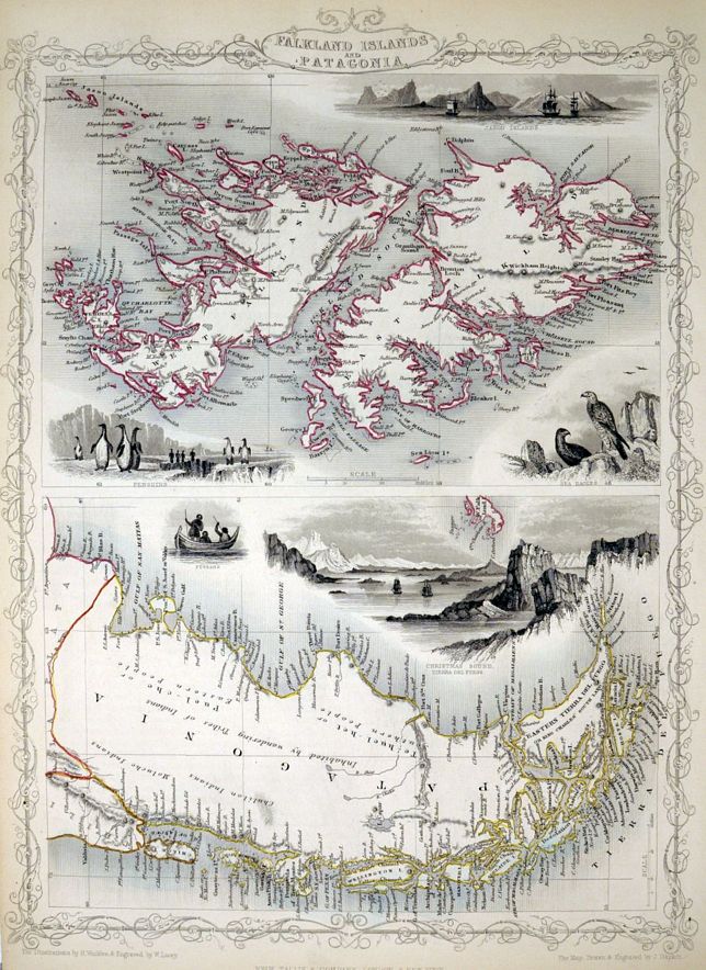
image

TALLIS, John.

Origin: London, John Tallis & Company, 1851.

Two maps on one sheet, with engraved vignettes including penguins and sea-eagles. John Tallis is without question one of the most renowned cartographers and publisher of the C19th. His maps are the last of the lavishly decorated and ornamental maps, considered to be works of art as well as geographically accurate. He was born in Stourbridge in Worcestershire in about 1818 and it is likely that he stayed in the Midlands working as a publisher in Birmingham, until he moved to London in the early 1840's.

Condition: Original outline colour; a fine unfolded example.

Size: 335 x 245mm (13¼ x 9¾ inches).

Reference: 7322

Price: £62

[this is simply us checking that you are a human!]

Guiane divisée en Guiane et Caribane.

image

SANSON, Nicholas.

Origin: Paris, c.1680.

A map ofGuiana, showing part of Venezuela, Guyana, Suriname, French Guiana and Amapa. Possibly engraved by Antoine de Winter for Sanson's "L'Amerique en Plusiers Cartes Nouvelles",

Condition: Coloured; light age-toning and spotting to margins, overall very good condition.

Size: 200 x 275mm (7¾ x 10¾ inches).

Reference: 13005

Price: £95

[this is simply us checking that you are a human!]

Il Cuscho Citta Principale Della Provincia del Peru.

image

MUNSTER, Sebastian.

Origin: Basle, Heinrich Petri, c.1580.

An early woodcut view of Cusco after Braun & Hogenberg, shows the surrounding countryside as well as the walled city. Knights, peasants and nobility can be seen both within and outside the walls of the city. The title is shown in a banner cartouche along the top.

Condition: Woodcut; slight darkening to centrefold caused by guard paste on verso, contemporary ink manuscript on verso, other light spotting and minor soiling, otherwise a good example.

Size: 275 x 370mm (10¾ x 14½ inches).

Reference: 11877

Price: £280

[this is simply us checking that you are a human!]

L'Amérique Méridionale Divisée en ses Principaux Etats.

image

ANON.

Origin: [Paris, c.1770].

A map of the whole of South America from a French atlas, the projection indicates a date around 1770-1800.

Condition: Coloured; small worm hole in the Atlantic Ocean area, otherwise a fine example.

Size: 175 x 220mm (7 x 8¾ inches).

Reference: 12215

Price: £48

[this is simply us checking that you are a human!]

L'Amerique Meridionale.

image

L'ISLE, Guillaume de.

Origin: Paris, 1700.

A map of South America, with decorative title cartouche. Shows the tracks of Magellan, Drake, Schouten, Le Maire and Mendaña.

Condition: Original outline colour; light age-toning and soiling to the margins, otherwise a good example.

Size: 455 x 595mm (18 x 23½ inches).

Reference: 10177

Price: £320

[this is simply us checking that you are a human!]

L'Amerique Meridonale...

image

L'Isle, Guilaume de.

Origin: Amsterdam, Covens & Mortier, 1730.

A rather distorted west coastline unlike many other maps of the period. Fine title cartouche and distance scales.

Condition: Original outline colour; slight overall age-toning, minor colour offsetting and spotting, otherwise a very good example.

Size: 460 x 580mm (18 x 22¾ inches).

Reference: 7591

Price: £420

[this is simply us checking that you are a human!]

Land-Kaart van het Eiland en de Volkplanting van Cayenne aan de Kust van Zuid-Amerika.

image

TIRION, Isaak.

Origin: Amsterdam, c.1740.

A map centred on Cayenne in French Guiana, with an inset plan of the fortified town.

Condition: Original body colour; top margin soft and cut close, without loss, some light soiling, otherwise a good example.

Size: 360 x 425mm (14¼ x 16¾ inches).

Reference: 10603

Price: £160

[this is simply us checking that you are a human!]

Le Paraguay subdivise enses proncipales parties...…

image

SANSON, Nicholas.

Origin: Paris, c.1680.

A map of Paraguay and the Rio de la Plata region, from Sanson's "L'Amerique en Plusiers Cartes Nouvelles", engraved by Antoine de Winter and published 1683.

Condition: Coloured; light age-toning and spotting to margins, overall very good condition.

Size: 210 x 275mm (8¼ x 10¾ inches).

Reference: 12941

Price: £90

[this is simply us checking that you are a human!]

Peru & Bolivia.

image

TALLIS, John.

Origin: London, John Tallis & Co., 1851.

With engraved vignettes including a prospect of Lima. John Tallis is without question one of the most renowned cartographers and publisher of the C19th. His maps are the last of the lavishly decorated and ornamental maps, considered to be works of art as well as geographically accurate. He was born in Stourbridge in Worcestershire in about 1818 and it is likely that he stayed in the Midlands working as a publisher in Birmingham, until he moved to London in the early 1840′s.

Condition: Original outline colour.

Size: 330 x 245mm (13 x 9¾ inches).

Reference: 2925

Price: £38

[this is simply us checking that you are a human!]

Peru, Bolivia, Chili & La Plata.

image

PHILIP & Son, George.

Origin: Liverpool, 1852.

A detailed map of the area.

Condition: Original coloured lithograph; light spotting and minor age-toning, otherwise a very good example.

Size: 625 x 505mm (24½ x 20 inches).

Reference: 12324

Price: £48

[this is simply us checking that you are a human!]

Peru, Chili and La Plata.

image

THOMSON & CO, John.

Origin: Edinburgh, John Thomson, 1821.

A detailed map of Peru, Chile, parts of Bolivia and Argentina. Published by John Thomson & Company in 'A New General Atlas'.

Condition: Original outline colour; light marginal soiling and age-toning to the edges of the paper, otherwise fine condition.

Size: 620 x 500mm (24½ x 19¾ inches).

Reference: 11185

Price: £98

[this is simply us checking that you are a human!]

South America from the latest Spanish and Portugese surveys.

image

WYLD, James.

Origin: London, 1825.

A detailed miniature map of South America.

Condition: Original Colour; slight age-toning to margins, otherwise good.

Size: 125 x 105mm (5 x 4¼ inches).

Reference: 4331

Price: £28

[this is simply us checking that you are a human!]

South America.

image

TALLIS, John.

Origin: London, John Tallis & Co.,1851.

With decorative engraved vignettes surrounding the map, gold mining in Brazil, Rio de Janeiro, Natives of Chile and the llama and condor of Peru. John Tallis is without question one of the most renowned cartographers and publisher of the C19th. His maps are the last of the lavishly decorated and ornamental maps, considered to be works of art as well as geographically accurate. He was born in Stourbridge in Worcestershire in about 1818 and it is likely that he stayed in the Midlands working as a publisher in Birmingham, until he moved to London in the early 1840′s.

Condition: Original outline colour; very minor marginal spotting but otherwise fine.

Size: 350 x 240mm (13¾ x 9½ inches).

Reference: 7494

Price: £130

[this is simply us checking that you are a human!]

South America.

image

S.D.U.K.

Origin: London, Thomas Letts, 1877.

The whole of South America. Engraved by J & C Walker.

Condition: Original outline colour; fine condition.

Size: 390 x 315mm (15¼ x 12½ inches).

Reference: 8863

Price: £32

[this is simply us checking that you are a human!]

South America.

image

THOMSON & CO, John.

Origin: Edinburgh, John Thomson, 1821.

A detailed map of South America, published by John Thomson & Company in 'A New General Atlas'.

Condition: Original outline colour; light marginal soiling and age-toning, otherwise fine condition.

Size: 590 x 500mm (23¼ x 19¾ inches).

Reference: 11197

Price: £120

[this is simply us checking that you are a human!]

South America.

image

FULLARTON & Co., Archibald.

Origin: Edinburgh, London & Dublin, c.1864.

A detailed map of the whole of South America, published in the 'Royal Atlas'.

Condition: Original colour; light toning and minor soiling, otherwise a very good example.

Size: 485 x 380mm (19 x 15 inches).

Reference: 12322

Price: £28

[this is simply us checking that you are a human!]

Suite du Perou. Audience de Lima.

image

BELLIN, Jacques Nicholas.

Origin: Paris, c.1760.

A map of Northern Peru, shows Lima.

Condition: Uncoloured; fine condition.

Size: 225 x 305mm (8¾ x 12 inches).

Reference: 5167

Price: £58

[this is simply us checking that you are a human!]

The Port of Callao, in the South Sea, with adjacent islands, rocks & coasts. To windward and leeward.

image

JEFFERYS, Thomas.

Origin: London, Gentleman's Magazine, c.1770.

The coast of Peru from the Port of China to Tomocayo Point, showing Callao near Lima (named), the Island of St Lorenzo and other landmarks such as Old Men's Port. Soundings in fathoms, with shoals and sand marked.

Condition: Uncoloured; signs of old folds, some print offsetting and trimmed close at bottom left corner due to binding, otherwise good.

Size: 210 x 365mm (8¼ x 14¼ inches).

Reference: 8411

Price: £80

[this is simply us checking that you are a human!]

Venezuela, New Granada, Equador, and the Guyanas.

image

TALLIS, John.

Origin: London, John Tallis & Co., 1851.

With engraved vignettes including views of Paramaribo and Chimborazo. John Tallis is without question one of the most renowned cartographers and publisher of the C19th. His maps are the last of the lavishly decorated and ornamental maps, considered to be works of art as well as geographically accurate. He was born in Stourbridge in Worcestershire in about 1818 and it is likely that he stayed in the Midlands working as a publisher in Birmingham, until he moved to London in the early 1840′s.

Condition: Original outline colour; minor spotting maily to title and very minor age-toning, otherwise very good.

Size: 250 x 330mm (9¾ x 13 inches).

Reference: 7723

Price: £48

[this is simply us checking that you are a human!]