Antique Maps of the Pacific Islands

Baye de Matavai a Otahiti - Havre D'Owharre dans L'Isle D'Huaneine - Havre D'Ohamaneno a Ulietea - Havre D'Oopoa a Ulietea.
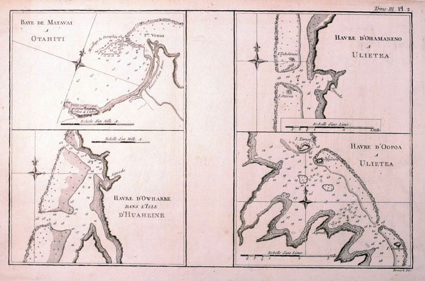
image

COOK, Capt. James.

Origin: [Paris, 1780.]

Four charts of the Society Islands on one sheet. Captain Cook and his crew first stopped in the Society Islands in 1769, and the islands became firm favourites of the crew. Shown are four protected bays on the islands of Otahiti (Tahiti), Ulietea (Raiatea), and d'Huaheine (Huahine), with numerous soundings, shoals, and anchorages noted. It was engraved by Benard.

Condition: Uncoloured; overall fine condition.

Size: 220 x 345mm (8¾ x 13½ inches).

Reference: 15461

Price: £65

[this is simply us checking that you are a human!]

Carte D'Assemblage de L'Océanique.

image

VANDERMAELEN, Phillipe Marie Guillaume.

Origin: Brussels, 1827.

A chart of the Oceania region and most of the Pacific Ocean, shows Australia, New Zealand and the Islands of the Pacific, published in the "Atlas Universel de Géographie

Condition: Original colour; light age-toning, otherwise a fine example.

Size: 455 x 650mm (18 x 25½ inches).

Reference: 12629

Price: £180

[this is simply us checking that you are a human!]

Carte des Isles découvertes aux environs D'Otahiti, dans plusieurs voyages suis autour du Monde par les Capitaines Byron, Wallis, Carteret et Cook en 1765, 1767, 1769.

image

COOK. Capt. James..

Origin: Paris, c.1770.

Detailed chart of the Society Islands in French Polynesia, showing Tahiti and the chain to the east, engraved by Benard.

Condition: Uncoloured; light spotting and marginal soiling, signs of old folds, otherwise very good.

Size: 245 x 520mm (9¾ x 20½ inches).

Reference: 5069

Price: £78

[this is simply us checking that you are a human!]

Carte des Isles de la Societé découvertés par le Lieut. J. Cook 1769.

image

COOK. Capt. James.

Origin: Paris, c.1770.

Detailed chart of the Society Islands in French Polynesia to the north west of Tahiti, showing Tubai, Borabora, Tahaa and Huahine.

Condition: Uncoloured; some minor waterstaining, light spotting and marginal soiling, signs of old folds, otherwise good.

Size: 295 x 440mm (11½ x 17¼ inches).

Reference: 5068

Price: £70

[this is simply us checking that you are a human!]

Carte des Isles des Amis.

image

BONNE, Rigobert.

Origin: Paris, c.1780.

Four maps on one sheet, the main one shows the islands of Tonga, orientated with north to the left, with insets of 'Plan du Havre de Tongataboo' and the islands of Mangeea, Tooboui and Wateeoo. Shows the tracks of the Resolution and the Discovery.

Condition: Uncoloured; very lght toning, otherwise a fine example.

Size: 230 x 350mm (9 x 13¾ inches).

Reference: 10144

Price: £48

[this is simply us checking that you are a human!]

Map of the Islands in the Pacific Ocean.

image

THOMSON & CO, John.

Origin: Edinburgh, John Thomson, 1821.

A detailed map of the Pacific Ocean, showing Queensland coast of Australia (named New South Wales) across to the Sandwich Islands (Hawaii) and down to the Society Islands (French Polynesia). Inset maps of Owhyhee, Karakakooa Bay, Otaheite and Matavia Bay (Otaheite). Published by John Thomson & Company in 'A New General Atlas' 1817.

Condition: Original outline colour; light marginal soiling and age-toning to the edges of the paper, slight darkening of centrefold due to guard paste, otherwise fine condition.

Size: 605 x 500mm (23¾ x 19¾ inches).

Reference: 11196

Price: £190

[this is simply us checking that you are a human!]

Oceania, or Islands in the Pacific Ocean, on Mercators Projection, comprising Polynesia, Malaysia and Australia.

image

FULLARTON & Co., Archibald.

Origin: London & Edinburgh, 1874.

The Pacific Ocean, with all the islands individually marked. From 'The Royal Illustrated Atlas of Modern Geography'.

Condition: Original coloured lithograph; short centrefold split at lower margin (repaired), otherwise a fine example.

Size: 400 x 500mm (15¾ x 19¾ inches).

Reference: 11816

Price: £60

[this is simply us checking that you are a human!]

Polynesia, or Islands in the Pacific Ocean.

image

TALLIS, John.

Origin: London, John Tallis & Co., c.1851.

Bordered by Japan top left, Australia bottom left and California top right, with four vignette views. John Tallis is without question one of the most renowned cartographers and publisher of the C19th. His maps are the last of the lavishly decorated and ornamental maps, considered to be works of art as well as geographically accurate. He was born in Stourbridge in Worcestershire in about 1818 and it is likely that he stayed in the Midlands working as a publisher in Birmingham, until he moved to London in the early 1840′s.

Condition: Original outline colour; minor marginal spotting, otherwise fine.

Size: 270 x 360mm (10¾ x 14¼ inches).

Reference: 7458

Price: £58

[this is simply us checking that you are a human!]