Antique Maps of Asia - Far East
Japan, China, Tartary, Indonesia, Malaysia, Philippines, Korea
A New Map of East India.

SPEED, John.
Origin: London, Bassett & Chiswell, 1627-76.
Condition: Finely coloured; expertly repaired lower centrefold, otherwise a fine example.
Size: 385 x 500mm (15¼ x 19¾ inches).
Reference: 8965
Price: £1650
Arachan & Pegu.

BERTIUS, Petrus.
Origin: Amsterdam, Judocus Hondius, 1616.
Condition: Uncoloured; very light overall age-toning and minor marginal staining, otherwise fine condition.
Size: 95 x 135mm (3¾ x 5¼ inches).
Reference: 9092
Price: £150
Carte de L'Empire du Japon.

BELLIN, Jacques Nicholas.
Origin: Paris, 1763.
Condition: Uncoloured; very slight age-toning, otherwise fine.
Size: 210 x 310mm (8¼ x 12¼ inches).
Reference: 7676
Price: £320
Carte de L'Isle de Sumatra...
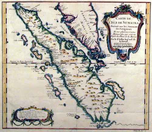
BELLIN, Jacques Nicholas.
Origin: Paris, c.1750.
Condition: Coloured; very light age-toning to the edges of the paper, trimmed close by the binder on the bottom margin, otherwise a good example.
Size: 250 x 295mm (9¾ x 11½ inches).
Reference: 10885
Price: £110
China and Burmah.

TALLIS, John.
Origin: London, London Printing & Publishing Co., 1851.
Condition: Original outline colour; very minor marginal soiling, otherwise a fine unfolded example.
Size: 260 x 320mm (10¼ x 12½ inches).
Reference: 7485
Price: £260
China veteribus Sinarum Regio nunc Incolis Tame dicta.

BLAEU, Willem.
Origin: Amsterdam, 1640, French text edition.
Condition: Fine original colour; very light age-toning ot he edges of the paper, minor spotting to margins, otherwise a fine example.
Size: 410 x 500mm (16¼ x 19¾ inches).
Reference: 12719
Price: £1850
Chinois.

MALLET, Alain Manesson.
Origin: Paris, 1683.
Condition: Coloured, highlighted with gum arabic; light soiling to margins, otherwise fine.
Size: 145 x 100mm (5¾ x 4 inches).
Reference: 13021
Price: £75
Die Insel Formosa neu abgemessen auf Befehl Kayser Kamhi

STOCKLEIN, Joseph S.J.
Origin: Augsburg, 1726.
Condition: Uncoloured; expertly repaired and laid on thick paper, now stable and a presentable example
Size: 180 x 230mm (7 x 9 inches).
Reference: 12313
Price: £680
Iaponiæ Nova Descriptio.

JANSSON, Johannes.
Origin: Amsterdam, 1636.
Condition: Fine colouring; overall a fine example, with only very minor marginal defects.
Size: 345 x 445mm (13½ x 17½ inches).
Reference: 4543
Price: £1450
Iedo.

MALLET, Alain Manesson.
Origin: Paris, 1683.
Condition: Coloured, highlighted with gum arabic; light soiling to margins, otherwise fine.
Size: 150 x 105mm (6 x 4¼ inches).
Reference: 13026
Price: £65
Ile de Baly ou Petite Java.

BELLIN, Jacques Nicholas.
Origin: Amsterdam, c.1765.
Condition: Uncoloured; minor waterstain to left margin, two small worm holes in lower margin, signs of old vertical folds from book, otherwise a good example.
Size: 200 x 230mm (7¾ x 9 inches).
Reference: 8227
Price: £140
Iles De L'Amirauté.

VANDERMAELEN, Phillipe Marie Guillaume.
Origin: Brussels, 1827.
Condition: Original coloured lithograph; overall fine condition.
Size: 470 x 540mm (18½ x 21¼ inches).
Reference: 12797
Price: £90
Imperio del Giappone.

TIRION, Isaac..
Origin: Venice, Girolamo Albrizzi, 1740.
Condition: Uncoloured; light centrefold toning due to guard paste, very light print offset and minor marginal staining, otherwise a fine example.
Size: 250 x 320mm (9¾ x 12½ inches).
Reference: 9770
Price: £480
Independent Tartary.

TALLIS, John.
Origin: London, John Tallis & Co., 1851.
Condition: Original outline colour; minor marginal spotting, otherwise fine.
Size: 250 x 320mm (9¾ x 12½ inches).
Reference: 7497
Price: £35
Indiæ Orientalis Nova Descriptio.

JANSSON, Johannes.
Origin: Amsterdam, Jan Jansson, 1606,, French text edition.
Condition: Original colour, light age-toning and minor marginal defects otherwise very good.
Size: 395 x 510mm (15½ x 20 inches).
Reference: 4673
Price: £1250
Isole di Sunda, Borneo, Sumatra, Iava Grande &c.

TIRION, Isaac..
Origin: Venice, Girolamo Albrizzi, 1740.
Condition: Uncoloured; light centrefold toning due to guard paste, very light print offset and minor marginal staining, otherwise a fine example.
Size: 280 x 370mm (11 x 14½ inches).
Reference: 9768
Price: £380
Japan & Corea.

TALLIS, John.
Origin: London, John Tallis & Co., 1851.
Condition: Original outline colour; minor spotting, hardly noticable, otherwise a fine example.
Size: 265 x 335mm (10½ x 13¼ inches).
Reference: 7484
Price: £170
Japan & Corea.

TALLIS, John.
Origin: London, John Tallis & Co., 1851.
Condition: Original outline colour; one or two light marginal spots, otherwise a fine example.
Size: unknown
Reference: 7621
Price: £170
Japonnois.

MALLET, Alain Manesson.
Origin: Paris, 1683.
Condition: Coloured, highlighted with gum arabic; light soiling to margins, otherwise fine.
Size: 155 x 105mm (6 x 4¼ inches).
Reference: 13027
Price: £48
L'Impero del Giapon...…

ZATTA, Antonio.
Origin: Venice, 1785.
Condition: Original colour; very light marginal staining, some old ink annotation in the upper margin, otherwise a fine example.
Size: 320 x 410mm (12½ x 16¼ inches).
Reference: 8510
Price: £580
La Chine.

AA, Pieter Van der.
Origin: Leiden, c.1713-14.
Condition: Uncoloured; minor staining to map and lower margin, signs of old folds, otherwise fine.
Size: 225 x 300mm (8¾ x 11¾ inches).
Reference: 7864
Price: £290
Malay Archipelago, or East India Islands.

TALLIS, John.
Origin: London, John Tallis & Company, 1851.
Condition: Original outline colour; trimmed by the binder along the bottom edge, with some loss of the publishers imprint, minor marginal soiling and light age-toning, otherwise a fine unfolded example.
Size: 265 x 330mm (10½ x 13 inches).
Reference: 10913
Price: £160
Miaco.

MALLET, Alain Manesson.
Origin: Paris, 1683.
Condition: Coloured, highlighted with gum arabic; light soiling to margins, otherwise fine.
Size: 150 x 105mm (6 x 4¼ inches).
Reference: 13019
Price: £65
Nieuwe Kaart van de Filippynsche, Ladrones, Moluccos of Specery Eilanden. Als mede Celebes etc.

TIRION, Isaak.
Origin: Amsterdam, 1744.
Condition: Fine original colour; minor age-tonig and spotting, otherwise very good.
Size: 285 x 330mm (11¼ x 13 inches).
Reference: 5917
Price: £350
Nieuwe Kaart van't Keizerryk Japan.

TIRION, Isaak.
Origin: Amsterdam, c.1735, Dutch version.
Condition: Original colour; minor staining and soiling to margins and a very slight sign of colour offsettin on the compass rose, otherwise a very good example.
Size: 280 x 320mm (11 x 12½ inches).
Reference: 7618
Price: £480
Palais de Jedo.

MALLET, Alain Manesson.
Origin: Paris, 1683.
Condition: Coloured, highlighted with gum arabic; light age-toning to margins, otherwise a fine example.
Size: 150 x 105mm (6 x 4¼ inches).
Reference: 13028
Price: £48
Partie De L'Archi. De La Nlle. Ireland.

VANDERMAELEN, Phillipe Marie Guillaume.
Origin: Brussels, 1827.
Condition: Original coloured lithograph; overall fine condition.
Size: 470 x 540mm (18½ x 21¼ inches).
Reference: 12798
Price: £68
Partie De L'Isle De Bornéo.

VANDERMAELEN, Phillipe Marie Guillaume.
Origin: Brussels, 1827.
Condition: Original coloured lithograph; overall fine condition.
Size: 470 x 540mm (18½ x 21¼ inches).
Reference: 12794
Price: £90
Partie De L'Isle De Bornéo.

VANDERMAELEN, Phillipe Marie Guillaume.
Origin: Brussels, 1827.
Condition: Original coloured lithograph; overall fine condition.
Size: 470 x 540mm (18½ x 21¼ inches).
Reference: 12795
Price: £90
Partie De L'Isle De Sumarta.

VANDERMAELEN, Phillipe Marie Guillaume.
Origin: Brussels, 1827.
Condition: Original colour; light age-toning, otherwise a fine example.
Size: 470 x 565mm (18½ x 22¼ inches).
Reference: 12648
Price: £110
Partie De L'Isle De Sumarta.

VANDERMAELEN, Phillipe Marie Guillaume.
Origin: Brussels, 1827.
Condition: Original colour; light age-toning, otherwise a fine example.
Size: 470 x 565mm (18½ x 22¼ inches).
Reference: 12650
Price: £150
Partie De L'Isle Sumarta.

VANDERMAELEN, Phillipe Marie Guillaume.
Origin: Brussels, 1827.
Condition: Original colour; light age-toning, otherwise a fine example.
Size: 470 x 565mm (18½ x 22¼ inches).
Reference: 12647
Price: £110
Partie De La Nouvelle Guinée.

VANDERMAELEN, Phillipe Marie Guillaume.
Origin: Brussels, 1827.
Condition: Original colour; light age-toning, otherwise a fine example.
Size: 470 x 560mm (18½ x 22 inches).
Reference: 12642
Price: £90
Partie De La Nouvelle Guinée.

VANDERMAELEN, Phillipe Marie Guillaume.
Origin: Brussels, 1827.
Condition: Original coloured lithograph; overall fine condition.
Size: 470 x 540mm (18½ x 21¼ inches).
Reference: 12796
Price: £75
Partie Des Iles Moluques.

VANDERMAELEN, Phillipe Marie Guillaume.
Origin: Brussels, 1827.
Condition: Original colour; light age-toning, otherwise a fine example.
Size: 470 x 565mm (18½ x 22¼ inches).
Reference: 12644
Price: £65
Partie de L'Inde au de la du Gange...…

SANSON, Nicholas.
Origin: Paris, 1683.
Condition: Coloured; light age-toning to the margins, overall a fine example.
Size: 190 x 250mm (7½ x 9¾ inches).
Reference: 13018
Price: £160
Peking.

MALLET, Alain Manesson.
Origin: Paris, 1683.
Condition: Coloured, highlighted with gum arabic; light soiling to margins, otherwise fine.
Size: 150 x 105mm (6 x 4¼ inches).
Reference: 13020
Price: £90
Plan du Port et de la Ville de Nangasaki.

BELLIN, Jacques Nicholas.
Origin: Amsterdam, 1736.
Condition: Coloured; signs of old folds from a smaller volume, otherwise a very good example.
Size: 200 x 445mm (7¾ x 17½ inches).
Reference: 11562
Price: £180
Regni D'Aracan del Pegu di Siam di Camboge e di Laos.

ZATTA, Antonio.
Origin: Venice, 1785.
Condition: Original outline colour; light toning and minor soiling mainly to the margins, overall a good example.
Size: 395 x 310mm (15½ x 12¼ inches).
Reference: 4061
Price: £280
Royaume du Iapon...…

BRIET, Philippe.
Origin: Paris, Pierre Mariette, 1658 -.
Condition: Original colour; very light stain, hardly noticable, manuscript 'Le Japon' on the blank verso, otherwise a fine example.
Size: 375 x 520mm (14¾ x 20½ inches).
Reference: 8277
Price: £1250
Tartaria.

MERCATOR, Gerard - HONDIUS, Henricus.
Origin: Amsterdam, 1606, French text edition.
Condition: Fine original colour; light age-toning, otherwise a fine example.
Size: 345 x 495mm (13½ x 19½ inches).
Reference: 10566
Price: £680
Terre de Jesso.

MALLET, Alain Manesson.
Origin: Paris, 1683.
Condition: Coloured, highlighted with gum arabic; light age-toning to the margins, otherwise a fine example.
Size: 150 x 105mm (6 x 4¼ inches).
Reference: 13033
Price: £110
Undecima Asiae Tabula.

PTOLEMY, Claudius.
Origin: Strassburg, Joannes Schott. 1513-20.
Condition: Woodcut; some expert restoration in the lower margin and to the centrefold area, only visible when held up to the light, light soiling, otherwise a very good example.
Size: 385 x 490mm (15¼ x 19¼ inches).
Reference: 12492
Price: £3250
