Antique Maps of Asia - Near East [D-L]
Holy Land, Arabia, Turkish Empire, Persia, Syria
A Compleat Map of the Holy Land; Adopted to the Old and New Testament: Part 1st & Part II.

DUNN, Samuel.
Origin: London, Robert Sayer, 1786.
Condition: Original outline colour; some spotting, mainly to the margin at the centrefold, minor print offset, otherwise good example.
Size: 340 x 485mm (13½ x 19 inches). Measurements are for each sheet approx.
Reference: 15947
Price: £340
A seven sheet map (two sheets joined) of the Holy Land (various titles).

HORNIUS, Georg. - JANSSON, Jan.
Origin: Amsterdam, Pieter de Hondt, 1677, blank verso.
Condition: Uncoloured; light spotting and minor toning, otherwise a fine example.
Size: 850 x 1770mm (33½ x 69¾ inches).
Reference: 16098
Price: £3200
De Stadt Ierusalem zoot Heden daeghs Bevonden wordt.

DAPPER, Olfert.
Origin: Amsterdam, 1677.
Condition: Uncoloured; fine dark impression with only minor age-toning to the edges of the margins, overall a fine example.
Size: 300 x 355mm (11¾ x 14 inches).
Reference: 15924
Price: £280
Descriptio et situs Terræ Sanctæ alio nimine Palestina...…

JODE, Gerard de.
Origin: Antwerp, 1593.
Condition: Uncoloured; very light age-toning, otherwise a fine example.
Size: 335 x 510mm (13¼ x 20 inches).
Reference: 12748
Price: £4800
Erster Abrisß der Stadt Jerusalem wie sie Fürnemlich zur Zeit deß Hern Christi beschaffen gewesen meistentheils genommen aus dem Tractur Christiani Adrichomij de Terra Sancta...

FLEISCHMANN, August Christian.
Origin: Nüremberg, 1736
Condition: Uncoloured; light marginal soiling, overall a fine example.
Size: 380 x 495mm (15 x 19½ inches).
Reference: 15890
Price: £620
Generaale Kaart van het Beloofde Land....

ELWE, Jan Bareld.
Origin: Amsterdam, 1792.
Condition: Original colour; some water staining to the upper margin just into printed area around the garland decoration, minor spotting and age-toning to the edges of the paper, otherwise a good example.
Size: 500 x 590mm (19¾ x 23¼ inches).
Reference: 15847
Price: £620
Iudæa seu Palæstina... hodie dicta Terra Sancta prout olim in Duodecim Tribus Divisa...

HOMANN, Johann Baptist.
Origin: Nurnberg, c.1707.
Condition: Original body colour; with possibly some recent embellishment on the title and figures. Trimmed very close on all four sides with some loss of outer printed line border, otherwise priced accordingly and fair condition.
Size: 490 x 573mm (19¼ x 22½ inches).
Reference: 15845
Price: £220
Iudæa sive Terra Sancta quæ Israelitarum suas duodecim tribus destincta... Per T. Danckerts.

DANCKERTS, Theodorus.
Origin: Amsterdam Justus Danckers, c.1698.
Condition: Full original colour; some ink manuscript page numbers in the margins, light age-tonning to the margins, overall very good.
Size: 507 x 574mm (20 x 22½ inches).
Reference: 15852
Price: £580
La Terre Sainte Tirée des Memoires de M.de la Ruë.

FER, Nicholas de.
Origin: Paris, 1705.
Condition: Uncoloured, dark impression, overall a fine example with accompanying text.
Size: 237 x 312mm (9¼ x 12¼ inches).
Reference: 15946
Price: £150
La Terre Sainte. Tirée des Memoires de M. de la Ruë.

FER, Nicholas de.
Origin: Paris, 1703.
Condition: Original outline colour; some vertical creasing to the left hand side of the map, short margin on the right with short nicks, reinforced with old paper. some minor soiling, printers crease across the mile scales and into map, two other maps of the region pasted on, otherwise a fair example.
Size: 290 x 575mm (11½ x 22¾ inches). Total size of all the maps.
Reference: 15957
Price: £160
Nouvelle Carte de la Terre Sainte Publieé en 1772.

DELAGRIVE, Jean.
Origin: Paris, Mondare, 1772.
Condition: Coloured; age-toning from a previous framing, minor nicks and short tears to margins and some rusty pin holes in each corner, otherwise a good example.
Size: 433 x 615mm (17 x 24¼ inches).
Reference: 16024
Price: £550
Novissima totius Terræ Sanctæ sive Promissionis Descriptio...…

FUNCK, David.
Origin: Nuremberg, c.1700.
Condition: Original colour; light age-toning and minor soiling to the margins, minor abrasion in the lower centrefold, overall very good.
Size: 470 x 563mm (18½ x 22¼ inches).
Reference: 15891
Price: £560
Palaestinae sive Totius Terrae Promissionis.

KAERIUS, Petrus.
Origin: Amsterdam, c.1600.
Condition: Uncoloured; light age-toning to the edges of the paper, otherwise a fine example.
Size: 155 x 200mm (6 x 7¾ inches).
Reference: 15458
Price: £120
Palestina, sive Terræ Sanctæ descriptio.
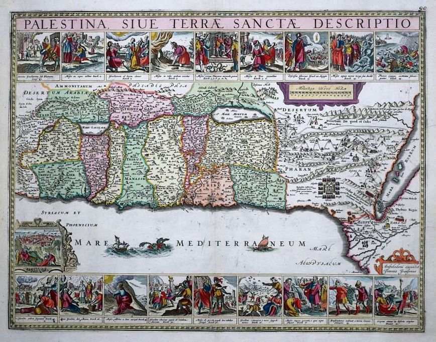
JANSSON, Jan.
Origin: Amsterdam, 1677.
Condition: Original colour; minor spotting, otherwise a fine example.
Size: 435 x 565mm (17¼ x 22¼ inches).
Reference: 12718
Price: £1950
Peregrinatie Iesu Christi: een ordentlicke bescrijvinge des Heijlighen landts daer ten tijde des Nieuwen Testaments

DOETECUM, Jnr, Johannes a.
Origin: Amsterdam, c.1614.
Condition: Uncoloured; some expert restoration to the centrefold and lower margin, minor repairs elsewhere, the whole now stable and very good.
Size: 303 x 490mm (12 x 19¼ inches).
Reference: 15828
Price: £580
Peregrinatio Israelitaru in Deserto.

HONDIUS, Jodocus/ PURCHAS, Samuel.
Origin: London, 1626.
Condition: Uncoloured; overall a fine example.
Size: 153 x 192mm (6 x 7½ inches).
Reference: 15955
Price: £98
Peregrinatio Pauli In qua & omnia quorum fit mentio in actis et epistolis Apostolorum et Apocalysi describuntur

HONDIUS, Jodocus/ PURCHAS, Samuel.
Origin: London, 1626.
Condition: Coloured; trimmed close at the right hand edge with no loss of printed surface, otherwise very good.
Size: 153 x 187mm (6 x 7¼ inches).
Reference: 15954
Price: £95
Pinax Geographicus Patriachatus Hierosolymitani...

LA RUE, Philippe de.
Origin: Paris, Pierre Mariette, 1651.
Condition: Original outline colour; light age-toning to the edges of the paper, some minor staining, otherwise a good example.
Size: 412 x 542mm (16¼ x 21¼ inches).
Reference: 15972
Price: £280
Platte Gront van Salomons Tempel, ten tyden des Zalighmakers volgens Thomas Fuller

FULLER, Thomas.
Origin: [Amsterdam, c.1700].
Condition: Uncoloured, dark impression; light age-toning to the edges of the margins, overall good condition.
Size: 295 x 360mm (11½ x 14¼ inches).
Reference: 15939
Price: £48
Primae Partis Asiae...…

JODE, Gerard de.
Origin: Antwerp, 1593.
Condition: Uncoloured; very light marginal soiling, otherwise a fine example.
Size: 300 x 510mm (11¾ x 20 inches).
Reference: 12742
Price: £2800
Regni Davidici et Salomonaei Descriptio Geographica cum vicinis regionibus Syriae et Aegypti . . . Schema II

HOMANN, Johann Baptist.
Origin: Nuremberg, 1739.
Condition: Original colour; dark impression, fine condition.
Size: 463 x 320mm (18¼ x 12½ inches). Map only + text.
Reference: 15848
Price: £280
Terræ Sanctæ Tabula...
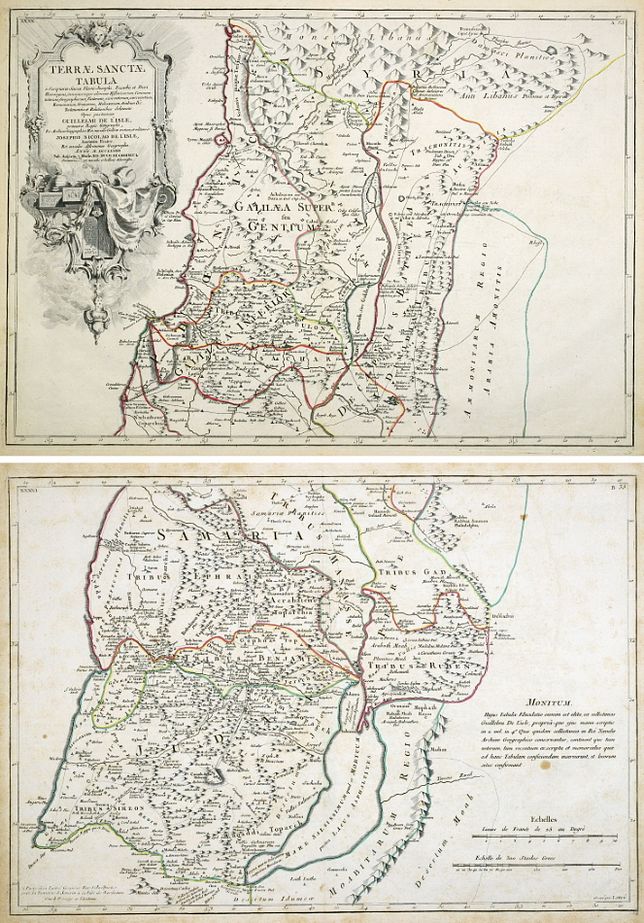
De L'ISLE, Guillaume & De L'Isle, Josephus Nicolas.
Origin: Paris, Lattré, 1782.
Condition: Original outline colour; light age-toning to the edges of the paper, otherwise good condition.
Size: 680 x 494mm (26¾ x 19½ inches). TWO SHEETS
Reference: 15835
Price: £480
Terra Promissa In Sortes Seu Tribus XII Distincta Seu Tabula Ad Librum Iosue.

LA RUE, Philippe de.
Origin: [Padua, 1694].
Condition: Superb original body colour; overall a fine example.
Size: 402 x 522mm (15¾ x 20½ inches).
Reference: 15952
Price: £420
Terra Sancta Promissionis olim Palestina.
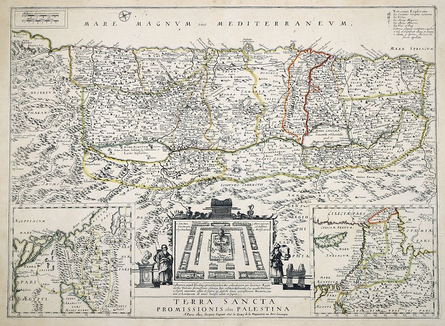
LAGNET, Jacques.
Origin: Paris, [1660].
Condition: Original outline colour; light marginal spotting, otherwise a fine example.
Size: 405 x 560mm (16 x 22 inches).
Reference: 15880
Price: £480
Terra Sancta sive Palaestina...

LOTTER, Tobias Conrad.
Origin: Augsburg, 1759.
Condition: Original body colour, light soiling along bottom edge and some light staining on the map, overall a good example.
Size: 485 x 578mm (19 x 22¾ inches).
Reference: 15842
Price: £420
Turcia Turcicive Imperii seu Solij mannorum regni pleraque pars, nunc recens summa fide ac in dustria elucumbrata.

JODE, Gerard de.
Origin: Antwerp, 1593.
Condition: Fine dark impression; very light age-toning, short split to lower part of centrefold in the margin, otherwise a fine example.
Size: 383 x 510mm (15 x 20 inches).
Reference: 12746
Price: £3500
Voyage des Enfans D'Israel. Dans le Desert Dspuis leur sortie D'Egypt par la Mer Rouge jusuau Pays de Canaan.

GLOT, C.B.
Origin: Paris, 1770-.
Condition: Uncoloured; slight overall age-toning and spotting, short tear in lower margin, otherwise good.
Size: 395 x 470mm (15½ x 18½ inches).
Reference: 15896
Price: £210
[No title].

ESKRICH, Pierre.
Origin: [Lyons, G Rouille, c.1573.
Condition: Uncoloured, woodcut; light water staining to the area of text above the map, otherwise a very good example.
Size: 170 x 215mm (6¾ x 8½ inches).
Reference: 16005
Price: £180
