Antique Maps of North Africa
Morocco, Algeria, Libya, Egypt
Ægyptus Hodierna Ex Itinerario Celeberrimi Viri. Pauli Lucæ...

HOMANN, Johan Baptist.
Origin: Nuremberg, c.1730.
Condition: Original body colour; very light marginal soiling, otherwise a good strong impression.
Size: 565 x 470mm (22¼ x 18½ inches).
Reference: 8940
Price: £280
Aegypti Recentior Descriptio - Carthaginis Celeberrimi sinus Typus.

ORTELIUS, Abraham.
Origin: Antwerp, 1612, Latin text edition.
Condition: Uncoloured; slight age-toning, minor spotting and soiling to margins, otherwise a good example.
Size: 320 x 230mm (12½ x 9 inches).
Reference: 12921
Price: £80
Aegyptus Antiqua.

JANSSON, Jan..
Origin: [Leiden, c.1640 or later.].
Condition: Coloured; short split to upper margin at centrefold (repaired), light marginal soiling, otherwise a very good example.
Size: 380 x 515mm (15 x 20¼ inches).
Reference: 10973
Price: £240
Africa of Lybien aan geene zyde, waar in leggen Saara of de Woestyne, 't Landt der Zwarten, Guinee, enz.

SANSON, Nicholas.
Origin: Paris, c.1705.
Condition: Uncoloured; light marginal age-toning and one minor nick well away from platemark, otherwise fine condition.
Size: 180 x 290mm (7 x 11½ inches).
Reference: 9359
Price: £85
Algérie Colonie Française.

LEVASSEUR, Victor.
Origin: Paris, 1852.
Condition: Original outline colour; minor age-toning to edges of margins, otherwise a fine example.
Size: 315 x 450mm (12½ x 17¾ inches).
Reference: 15407
Price: £48
Algier. Fortificato Di Novo MD LXXI.
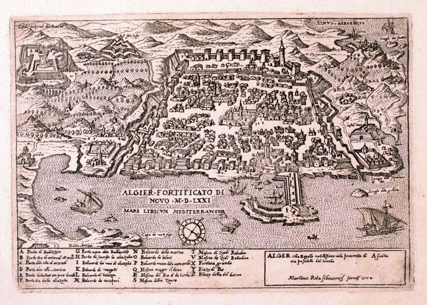
VALEGIO, Francesco.
Origin: Venice, 1595.
Condition: Uncoloured; light water staining, mainly to margins, otherwise a fine dark impression.
Size: 85 x 120mm (3¼ x 4¾ inches).
Reference: 9576
Price: £120
Barbaria pars Africae, Comprae: hendens praecipua Loca versus littoria Maris Mediterranei.
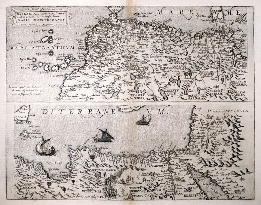
JODE, Gerard de.
Origin: Antwerp, 1593.
Condition: Fine dark impression; very light age-toning to the upper part of centrefold, otherwise a fine example.
Size: 355 x 455mm (14 x 18 inches).
Reference: 12745
Price: £750
Barbaria pars Apricæ, Compræhendens precipua Loca Versus littora Maris Mediterranei.

DE JODE, Gerard.
Origin: Antwerp, 1593, Latin text edition.
Condition: Uncoloured; light spotting noticeable in the margins, light age-toning to centrefold, otherwise a fine example.
Size: 360 x 460mm (14¼ x 18 inches).
Reference: 13669
Price: £560
Barbaria.

HONDIUS, Henricus.
Origin: Amsterdam, Henricus Hondius, 1636, English text edition.
Condition: Original colour; minor defects mostly confined to the lower part of centrefold and slight soiling to the margins, otherwise a very good example.
Size: 355 x 470mm (14 x 18½ inches).
Reference: 7037
Price: £210
Barbary.

GIBSON, John.
Origin: London, 1792.
Condition: Uncoloured; brown stain in upper margin, otherwise fine condition.
Size: 65 x 95mm (2½ x 3¾ inches).
Reference: 7636
Price: £21
Cairus quae olim Babylon; Aegypti Maxima Urbs.

BRAUN, Georg & HOGENBERG, Franz.
Origin: Cologne, 1574-.
Condition: Coloured; some minor marginal soiling, small nicks to the edge of the paper, otherwise a fine example.
Size: 335 x 480mm (13¼ x 19 inches).
Reference: 8063
Price: £850
Cairus quae olim Babylon; Aegypti Maxima Urbs.

BRAUN, Georg & HOGENBERG, Franz.
Origin: Cologne, 1574-.
Condition: Coloured; some soiling and staining mainly to margins, minor marginal nicks, otherwise a good example.
Size: 335 x 480mm (13¼ x 19 inches).
Reference: 11610
Price: £690
Carte Du Golfe D'Arabie, Depuis Suez a Bab-El - Mander.

BRUCE, James.
Origin: [Paris, c.1805].
Condition: Uncoloured; signs of old folds from a smaller volume, light toning and minor staining to the margins, overall very good condition.
Size: 622 x 500mm (24½ x 19¾ inches).
Reference: 16030
Price: £240
Carte de la Barbarie, Nigritie et de la Guinée avec les Pays Voisins.

CHATELAIN, Henri Abraham.
Origin: Amsterdam, c.1719.
Condition: Uncoloured; dark impression, fine condition.
Size: 400 x 510mm (15¾ x 20 inches).
Reference: 10289
Price: £280
Egypt and Arabia Petræa.

TALLIS, John.
Origin: London, John Tallis & Company, 1851.
Condition: Original outline colour; very light age-toning to the edges of the margins, otherwise a fine unfolded example.
Size: 360 x 250mm (14¼ x 9¾ inches).
Reference: 7492
Price: £78
Egypte divisée en see Douze Cassilies ou Gouvernemens.

SANSON, Nicholas.
Origin: Paris, c.1680.
Condition: Coloured; light age-toning and spotting to margins, overall very good condition.
Size: 275 x 205mm (10¾ x 8 inches).
Reference: 13007
Price: £90
In Notitiam Ecclesiasticam Africæ Tabula Geographica.

L'ISLE, Guillaume de.
Origin: Paris, 1700.
Condition: Original outline colour; light age-toning and soiling to the margins, otherwise a good example.
Size: 485 x 640mm (19 x 25¼ inches).
Reference: 10163
Price: £130
L'Egitto Antico e Moderno.

ZATTA, Antonio.
Origin: Venice, 1784.
Condition: Original colour; light marginal staining, sign of old vertical crease near centrefold, manuscript annotation in upper margin, otherwise a good example.
Size: 420 x 310mm (16½ x 12¼ inches).
Reference: 8516
Price: £98
Lower Egypt and the Adjacent Deserts, with a Part of Palestine; to which has been added the nomenclature of the Roman age by L.S. de La Rochette.
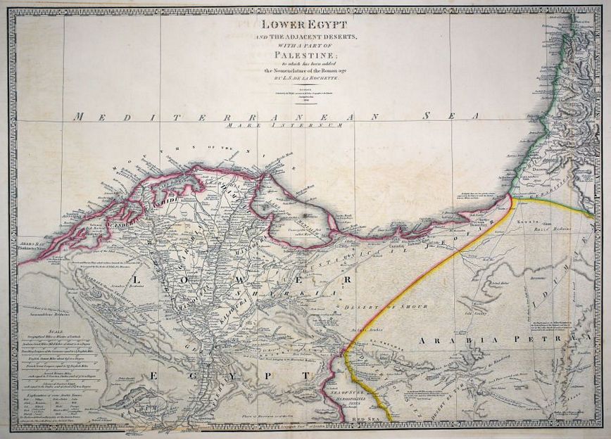
WYLD, James.
Origin: London, 1843.
Condition: Original outline colour; light print offset, minor marginal spotting, otherwise a fine example.
Size: 535 x 745mm (21 x 29¼ inches).
Reference: 11311
Price: £190
Northern Africa.

TALLIS, John.
Origin: London, John Tallis & Co., c.1851.
Condition: Original outline colour; very minor marginal spotting, otherwise a fine unfolded example.
Size: 250 x 340mm (9¾ x 13½ inches).
Reference: 7470
Price: £38
