Antique Maps of Asia - Near East [A-C]
Holy Land, Arabia, Turkish Empire, Persia, Syria

Jerusalem, et suburbia eius, sicut tempore Christi floruit cum locis in quibus Christus passus est quae religiose a Christianis observata etia nu Venerationi habetur descripta per Christianum Adrichom Delphum.

image

ADRICHOM, Christian van.

Origin: Cologne, 1590-1682.

A large and fine two sheet plan of Jerusalem, originally published in Adrichom's "Theatrum Terrae Sanctae", which was published in Cologne in 1590. This is a later edition from 1682. Christian van Adrichom (1533-1585) was a Dutch priest, his scholarly research of the Bible and writings of pilgrims and Josephus made him the acknowledged expert on the geography and history of the Holy Land. Josephus was a Jewish historian who was employed by the Romans to write about the history of Roman Palestine during the Jewish revolt of 60-70 AD. This plan shows 269 sites and scenes of Jerusalem, both within and outside the city walls. Each depicting an item mentioned in the Scriptures, and other historical and traditional sources.

Condition: Uncoloured; two sheets joined, light creasin and signs of old folds, short tear in left-hand margin (from book), otherwise a very good example.

Size: 520 x 745mm (20½ x 29¼ inches).

Reference: 15772

Price: £1850

[this is simply us checking that you are a human!]

A Correct Map of the Countries surrounding the Garden of Eden or Paradise, with the course of Noah's Ark during the Flood &c.

image

BOWEN, Thomas.

Origin: London, 1785.

This map shows the Old Testament biblical lands from the Caucasus south to the Persian Gulf, including parts of present day Iraq, Iran, Turkey, Kuwait, Armenia, Azerbaijan & Georgia. The Black Sea and Caspian seas are marked. Noah is indicated to have built the Ark at Cyparisson, near Mosul in present-day Iraq, before piloting it to Jawat, near Baku in present day Azerbaijan, and then on to a curiously misplaced Mount Ararat, shown on the map to be in present-day western Iran (it is in fact in far eastern Turkey).

Condition: Original outline colour; light toning and water stain to top of upper margin, otherwise very good.

Size: 295 x 180mm (11½ x 7 inches).

Reference: 16065

Price: £110

[this is simply us checking that you are a human!]

A Draught of the City of Jerusalem as it is now, taken from the south east by Corneille le Bruyn.

image

BRUYN, Corneille le.

Origin: [London, 1737].

The modern city of Jerusalem from the South-East, by Corneille Le Bruyn. With a key along the bottom to 25 prominent sites in Jerusalem. In the upper left corner: "Vol. I. page 461". Engraved by James Hulett.

Condition: Uncoloured; cery light age-toning to the edges of the paper, otherwise fine condition.

Size: 140 x 313mm (5½ x 12¼ inches).

Reference: 16106

Price: £180

[this is simply us checking that you are a human!]

A Map of the Countries where the Apostles Travell'd and of the other places mentioned in the Acts &c.

image

CONDER, Thomas.

Origin: London, c.1801.

A map of the Eastern Mediterranean, with inset map of the remote places mentioned in the New Testament. Engraved for the Reverend Doctor Wright's 'Complete British Family Bible'.

Condition: Coloured; light marginal toning and spotting, overall good.

Size: 282 x 185mm (11 x 7¼ inches).

Reference: 15903

Price: £48

[this is simply us checking that you are a human!]

An Accurate Map of Asia Minor as Divided into its Provinces before it became possess'd by the Turks. Laid down from the most approved Maps.
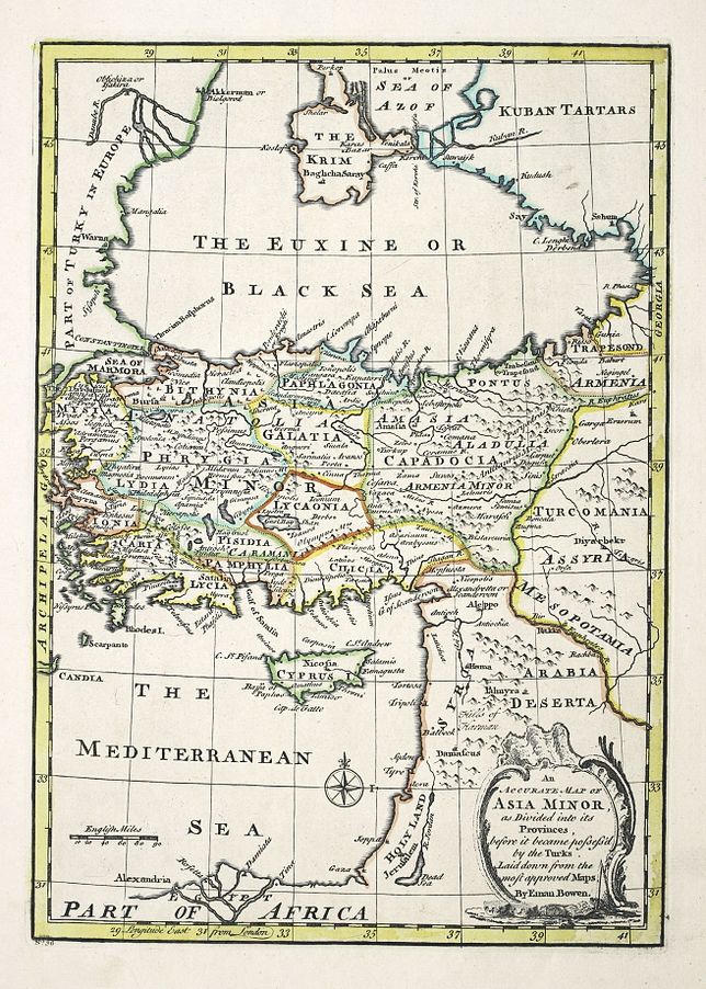
image

BOWEN, Emanuel.

Origin: London, 1744.

A map showing Turkey, the Black Sea and the Middle East down to the Nile Delta. Decorative rococo style title cartouche and a compass rose.

Condition: Original outline colour; very minor age-toning to the edges of the paper, otherwise a fine example.

Size: 330 x 233mm (13 x 9¼ inches).

Reference: 16072

Price: £160

[this is simply us checking that you are a human!]

An Accurate Map of the Holy Land Divided into the XII Tribes of Israel. Accomodated to Sacred History, & describing the Travels of Jesus Christ.

image

BOWEN, Thomas.

Origin: London, 1752.

Decorative rococo style title cartouche, published in 'A complete atlas or distinct view of the known world'.

Condition: Original outline colour; light age-toning to the edges of the paper, otherwise a fine example.

Size: 323 x 230mm (12¾ x 9 inches).

Reference: 16073

Price: £190

[this is simply us checking that you are a human!]

Antiquæ Ierusalem vera Icnographia Ad Sacræ Lectionis Præcipue et Aliarum de Illa Urbe Historiar. Expiicationem Ex collatione actoru cu ruinaru uestigijsac Situ ipso...

image

ARIAS MONTANUS, Benedictus.

Origin: Leyden, 1593.

This imaginary view of ancient Jerusalem was originally published in 1572 by Christopher Plantin in 'Nehemias, sive, de antiquae Ierusalem sitv', in 'Biblia polyglotta'. The map is engraved by Pieter van der Heyden and was possibly drawn after Laicstain's original. 'Arias Montanus (1527-1598) the Spanish orientalist whose polyglot edition of the Bible caused him to be denounced by the Inquisition, but he was later acquitted. This example from 'Antiquitatum Judaicarum' was published in Leyden 1593.

Condition: Uncoloured; light staining and spotting, tear to left hand margin and into printed surface and repaired in a rather amateurish way with old paper from the book, otherwise a fairly good example.

Size: 283 x 242mm (11¼ x 9½ inches).

Reference: 15959

Price: £240

[this is simply us checking that you are a human!]

Antiquæ Jerusalem Vera Icnographia...

image

ARIAS MONTANUS, Benedictus.

Origin: Antwerp, Christopher Plantin, 1572-.

This imaginary view of ancient Jerusalem was originally published in 1572 by Christopher Plantin in 'Nehemias, sive, de antiquae Ierusalem sitv', in 'Biblia polyglotta'. The map is engraved by Pieter van der Heyden and was possibly drawn after Laicstain's original. 'Arias Montanus (1527-1598) the Spanish orientalist whose polyglot edition of the Bible caused him to be denounced by the Inquisition, but he was later acquitted.

Condition: Uncoloured; overall age-toning, light staining and spotting, signs of old folds, otherwise a good example.

Size: 285 x 240mm (11¼ x 9½ inches).

Reference: 15448

Price: £120

[this is simply us checking that you are a human!]

Belegering van Jerusalem, Door Nebucannezar.

image

CALMET, Augustin.

Origin: Leiden, 1732.

Finely engraved view of Jerusalem, showing the city as it is described in the Second Book of Kings, Chaper 25:1 in the Old Testament: "And it came to pass in the ninth year of his kingdom, on the tenth day of the tenth month Nebuchadnezzar king of Babylon came with all his might against Jerusalem, and they encamped against it and built bastions around it". Published in 'Byvoegzel tot het algemeen groot Naamen Woord-Boek van den ganschen H. Bybel' by Augustin Calmet.

Condition: Uncoloured; some light age-toning to the edges of the paper, minor soiling to the margins, otherwise a very good example.

Size: 300 x 447mm (11¾ x 17½ inches).

Reference: 15928

Price: £190

[this is simply us checking that you are a human!]

Canaan comonly called the Holy Land or the Land of Promise, being the Possession of the Israelites & travelled through by our Lord & Saviour Iesus Christ and his Apostles.

image

BLOME, Richard.

Origin: London, 1687.

A map of the Holy Land, with west at the top of the page, the shoreline runs from Rinocurura to Biblium. Shows the division of land at the time of Jesus into Galilee, Samaria and Judea. Probably published in an English Bible at the end of the 17th century. A reduced version of Nicholas Visscher's map without decoration and engraved by Richard Palmer.

Condition: Coloured; overall fine condition.

Size: 267 x 462mm (10½ x 18¼ inches).

Reference: 16006

Price: £320

[this is simply us checking that you are a human!]

Carte Générale pour servir a l'Intelligence de l'Histoire Sainte, principalement par raport a ses Premiers Ages.

image

BUACHE, Philippe.

Origin: Paris, 1754.

A general map of the Middle East region for the understanding of Sacred History, especially as far as the earliest ages. Shows also Asia Minor and as far as Persia and the Caspian Sea and from the Black Sea to the Persian Gulf and the Red Sea. Probably published in 'Cartes et tables de la géographie physique'.

Condition: Original outline colour; light soiling to the margins, overall a fine example.

Size: 255 x 327mm (10 x 12¾ inches).

Reference: 15966

Price: £160

[this is simply us checking that you are a human!]

Carte Particulière des Pais ou les Apôtres ont Prêché l'Evangile...

image

COVENS, Johannes & MORTIER, Cornelius.

Origin: Amsterdam, c.1725.

A map of the Eastern Mediterranean, from Italy to Cyprus, also showing the Black Sea and part of the Caspian. Also shows the route of St Paul on his way to Rome.

Condition: Original body colour; trimmed to just outside the plate mark top and bottom, side margins slightly wider, signs of old folds and minor oxidation of green showing on verso, overall a good example.

Size: 397 x 467mm (15¾ x 18½ inches).

Reference: 16062

Price: £180

[this is simply us checking that you are a human!]

Carte de la Syrie.

image

BELLIN, Jacques Nicolas.

Origin: [Paris, 1764].

An engraved map of the eastern Mediterranean, published in Jacques Nicolas Bellin's 'Le Petit Atlas Maritime Recueti de Cartes et Plans des Quatre Parlies du Monde en Cinq Volumes', first published in Paris in 1764. The map shows the coastline from Gaza to the Turkish coast.

Condition: Coloured; minor marginal spotting and age-toning, otherwise a very good example.

Size: 215 x 170mm (8½ x 6¾ inches).

Reference: 15985

Price: £75

[this is simply us checking that you are a human!]

Carte du Paradia Terrestre Suivant le Systême de Mr Huet et Executé par P. Starck-Man / Carte du Paradis Terrestre Suivant le Systême de l'Auteur et Executé par P. Starck-Man.

image

CALMET, Augustin - STARCKMAN, P.

Origin: Paris, c.1720.

Two maps on one sheet, each showing a different location for the Garden of Eden. The first, illustrating the theories of Mr. Huet, showing a larger area, with Eden located south of Babilone (present-day Baghdad) and just north of the Persian Gulf. The second according to Calmet, shows Paradise located in present-day Armenia near Mount Ararat. Both were drawn and engraved by P. Starckman, with added compass roses and attractive rococco style title cartouches.

Condition: Uncoloured; water staining to the margins and centrefold, not affecting the printed area, some light print offset, otherwise a very good.

Size: 240 x 468mm (9½ x 18½ inches), total size.

Reference: 16055

Price: £230

[this is simply us checking that you are a human!]

Carte du Voïage des Israelïtes dans le desert, depuis leur Sortie de l'Egipte jusquau passage du Jourdain.

image

CALMET, Augustin Antoine.

Origin: Paris, 1724.

A decorative map of the Exodus, the map is surrounded by ten vignettes showing the Tabernacle and part of the Temple vessels. Published in 'Commentaire littéral sur tous les livres de l'Ancien et du Nouveau Testament'. Engraved by Jean Baptiste Liebaux.

Condition: Uncoloured; light age-toning to the edges of the paper, trimmed close on the right hand margin, with no loss of printed surface, otherwise a fine example.

Size: 238 x 356mm (9¼ x 14 inches).

Reference: 16100

Price: £98

[this is simply us checking that you are a human!]

Carte du Voyage des Israelites dans le desert.

image

BENARD, Jaques Francois.

Origin: Paris, 1742.

A map of the wanderings of the Israelites through the desert from Egypt to Jordan.

Condition: Uncoloured; signs of old folds from a smaller volume, some age toning to one of the folds, short tear at the upper edge with old paper repair, otherwise a dark impression.

Size: 210 x 320mm (8¼ x 12½ inches).

Reference: 15808

Price: £50

[this is simply us checking that you are a human!]

Charte vom Osmannischen Reiche in Asien. Prag 1811.

image

ANON.

Origin: Prague, 1811.

A map of the Ottoman Empire, originally published in Weimar in 1806.

Condition: Original outline colour; print and colour offset, light toning to the margins, old folds from a smaller volume, overall very good.

Size: 294 x 410mm (11½ x 16¼ inches).

Reference: 15871

Price: £160

[this is simply us checking that you are a human!]

Conspectus Libani atque Antilibani secundum observationes H. Maundrelli, ex autographo ejus descriptus.

image

BROEN, Joannes de.

Origin: Amsterdam, c.1700.

A map primarily of the Lebanon by Henry Maundrell and engraved by Joannes de Broen.

Condition: Uncoloured; old folds from an 8vo size volume strengthened on verso, otherwise very good.

Size: 380 x 246mm (15 x 9¾ inches).

Reference: 15861

Price: £150

[this is simply us checking that you are a human!]

Het Heylige Land verdeeld in de Twaalf Stammen Israels...

image

COVENS, Jean. & MORTIER, Corneille.

Origin: Amsterdam, c.1700.

A finely engraved map of the Holy Land showing the twelve Tribes. Engraved by Johannes van Luchtenburgh.

Condition: Uncoloured; very light age-toning to the edges of the margins, short nicks to the edges of the paper, otherwise overall fine condition.

Size: 400 x 470mm (15¾ x 18½ inches).

Reference: 15825

Price: £280

[this is simply us checking that you are a human!]

Hierosolyma, Clarissima totius Orientis ciuitas, Iudaee Metropolis...

image

BRAUN, George & HOGENBERG, Franz.

Origin: Cologne, 1572-.

From the first volume of Braun & Hogenberg's 'Civitates orbis terrarum'. Two plans of Jerusalem on one sheet, one an imaginary description of the ancient city of Jerusalem at the time of Christ, and the other a topographical description of the modern city. Moses receiving the tablets of the Law appears in a small inset at bottom right.

Condition: Original colour; some soiling and staining, other marginal spotting, toning and tears, particularly around the lower centrefold, one longer tear into plate mark has been repaired with old paper, probably done in the book, priced accordingly.

Size: 342 x 487mm (13½ x 19¼ inches).

Reference: 15921

Price: £380

[this is simply us checking that you are a human!]

Irak Arabi Kurdistan Diarbek Turcomannia Siria e Palestina.

image

ALBRIZZI, Giovanni. - TIRION, Isaac..

Origin: [Venice, 1742].

A map showing the Middle Eastern region from Cyprus, Turkey across to the Caspian Sea and down to Persian Gulf.

Condition: Uncoloured; light toningto the centrefold due to guard paste, otherwise a fine example.

Size: 277 x 338mm (11 x 13¼ inches).

Reference: 15987

Price: £190

[this is simply us checking that you are a human!]

J. Newbery Reyaweg over Zee en Land na Tripoli Aleppo Persien Armenien en d Eylanden der Middlellandze Zee.

image

AA, Pieter van der.

Origin: Leiden, 1713.

A map of the Eastern Mediterranean Sea, shows the region from Romania to the Caucasus, and from Egypt to the Persian Gulf, with Cyprus and the Holy Land. Published in "Le Nouveau Theatre du Monde".

Condition: Coloured; old vertical folds from a smaller volume, repaired tear to upper margin, otherwise good.

Size: 153 x 230mm (6 x 9 inches).

Reference: 15866

Price: £65

[this is simply us checking that you are a human!]

Jerusalem die heilige vierecete Stadt/ in Grund gelegt, und eigentlich abgemalet.

image

BÜNTING, Heinrich.

Origin: Magdeburg, 1581.

Heinrich Bunting was a theologian from Hanover. His 'Itinerarium Sacrae Scriptura', published in 1581, provided the most complete summary of biblical geography available. It described the Holy Land by following the travels of various notable people from the Old and New Testaments. This imaginary plan of the Holy City of Jerusalem as seen from the east is one of nine woodcuts that appear in the book.

Condition: Original coloured woodcut; lightly age-toned, minor staining to the margins, trimmed close along bottom edge, with no loss of printed surface, small nicks to edges of paper, otherwise a good example.

Size: 280 x 370mm (11 x 14½ inches).

Reference: 16063

Price: £360

[this is simply us checking that you are a human!]

Judæa Seu Duodecim Tribus Israelis.

image

BONNE, Rigobert.

Origin: Paris, 1787.

A map of the Holy Land as divided into the 12 Tribes of Israel. The sane map as the French original edition, without the the explanatory text and cartouche. Engraved by André and published in 'Atlas encyclopédique'.

Condition: Coloured; light age-toning to the margins, overall fine condition.

Size: 354 x 240mm (14 x 9½ inches).

Reference: 16105

Price: £90

[this is simply us checking that you are a human!]

La Judée ou Palestine. Dressée pour l'Intelligence de l'Histoire Sainte.

image

BRION DE LA TOUR, Louis.

Origin: Paris, Desnos, 1767.

Decorative map of the Holy Land drawn from the understanding of the Sacred History, within a separately printed border simulating an ornate frame. Published in Louis Brion de la Tour's "Atlas Général, civil et ecclésiastique".

Condition: Original colour; light age-toning to the edges of the margins, small hole in the bottom left corner of the righ margin, overall a very good example.

Size: 273 x 310mm (10¾ x 12¼ inches).

Reference: 15862

Price: £180

[this is simply us checking that you are a human!]

Land Tafel darinnen die gegendt des Paradijs das land Canaan...

image

BOECKLER, Georg. Andreas.

Origin: Wittenberg, c.1660.

A rare map of the Holy Land published in Wittenberg, Germany. It was issued for Martin Luther's Protestant translation of the Bible along with other maps drawn by Georg Andreas Boeckler. His work is rare and few examples have survived. NOT IN LAOR. This map covers the Eastern Mediterranean and the Middle East to the Persian Gulf and Red Sea. Two portraits adorn either side of the title in German, those of Adam and Eve.

Condition: Coloured; this map is rarely found without condition issues, this example has been re-margined at the sides with old paper, short nick into plate mark along the tope edge, otherwise it is quite good.

Size: 262 x 405mm (10¼ x 16 inches).

Reference: 16000

Price: £650

[this is simply us checking that you are a human!]

Nouveau Plan du Temple de Jerusalem.

image

CALMET, Augustin Antoine.

Origin: Paris, 1724.

A plan of the new Temple in Jerusalem. Published in 'Commentaire littéral sur tous les livres de l'Ancien et du Nouveau Testament'. Probably engraved by Jean Baptiste Liebaux.

Condition: Uncoloured; light age-toning to the edges of the paper, trimmed close on the left hand margin, with no loss of printed surface, otherwise a fine example.

Size: 218 x 116mm (8½ x 4½ inches).

Reference: 16102

Price: £48

[this is simply us checking that you are a human!]

Palæstinæ seu Terræ Promissionis in duo decim Tribus partiæ Faies Antiqua... Davidici et Solomonæi Imperii...

image

BLAIR, Rev John.

Origin: London, 1768.

Palestine or the Land of Promise divided among the 12 Tribes, with the route of the Israelites through the desert as well as the empire of David and Solomon.. The map shows the whole of the Middle East from Crete to Babylonia. Published in Blair's "Chronology and History of the World".

Condition: Dark impression, uncoloured; overall fine condition.

Size: 423 x 578mm (16¾ x 22¾ inches).

Reference: 15851

Price: £210

[this is simply us checking that you are a human!]

Palæstinæ sive Terræ Promissionis in duo decim Tribus partie Facies Vetus.

image

BLAIR, Rev John.

Origin: London, 1768.

A map of the Promised Land divided among the Tribes on both sides of the Jordan. Published in Blair's "Chronology and History of the World". The map is after D'Anvlle's Palestine without the insets.

Condition: Dark impression, uncoloured; overall fine condition.

Size: 420 x 570mm (16½ x 22½ inches).

Reference: 15850

Price: £230

[this is simply us checking that you are a human!]

Palæstina seu Terra Sancta.

image

CELLARIUS, Christophor.

Origin: [London, c.1745].

A map of the Holy Land probably published in Cellarius's 'Geographia Antiqua', London S.Ballard, M.Senex, G.Innys, T.Longman & T.Shewell.

Condition: Uncoloured; folds from a smaller volume, otherwise a fine example.

Size: 208 x 147mm (8¼ x 5¾ inches).

Reference: 13631

Price: £52

[this is simply us checking that you are a human!]

Palaestina.

image

BERTIUS, Petrus.

Origin: Amsterdam, Cornelis Claesz, 1606, Latin text edition.

A miniature map of the Holy Land, engraved by Keere. First published 1598 by Barent Langenes, with later editions with text by Bertius, the maps became known by these two names: however this edition has a new text by Jacobus Viverius and is published by Claesz. In the Mediterranean a galleon is being attacked by a twin-spouted sea-monster, with a man falling overboard. Published in 'Tabularum Geographicarum Contractarum Linri Quinque'.

Condition: Uncoloured; dark impression, fine condition.

Size: 90 x 125mm (3½ x 5 inches).

Reference: 15814

Price: £120

[this is simply us checking that you are a human!]

Palestina et Syria.

image

BONNE, Rigobert.

Origin: [Venice, A. Santini, 1794].

A map of the Middle East, also showing southern Turkey, along the coastline to 'Rhinocorura' and part of Cyprus.

Condition: Origonal outline colour; light age-toning to the edges of the paper, minor spottng, otherwise a very good example.

Size: 325 x 220mm (12¾ x 8¾ inches).

Reference: 16104

Price: £85

[this is simply us checking that you are a human!]

Palestina seu Terra Sancta.

image

ANON.

Origin: c.1700

A map of the Holy Land, NOT IN LAOR.

Condition: Coloured; signs of old folds from a smaller volume, overal very good.

Size: 205 x 145mm (8 x 5¾ inches).

Reference: 15868

Price: £34

[this is simply us checking that you are a human!]

Palestinae Delineatio ad Geographiae Canones Revocata...…

image

BRIET, Philippe.

Origin: Paris, chez Pierre Mariette, 1641.

A map of the Holy Land oriented to the east and divided according to the tribes on both sides of the Jordan. Above are three smaller maps showing the Eastern Mediterranean. A plan of the ancient city of 'Hiervsalem' and the third showing the wanderings of the tribes from Ramses in Egypt through the Red Sea and the Sinai Peninsula until they reached Palestine. Engraved by Henri le Roy and published in 'La Terre Saincte en six cartes géographiques'.

Condition: Original outline colour; short centrefold split, small rusted pin holes in the margins, light age-toning to the edges of the paper, otherwise good condition.

Size: 395 x 545mm (15½ x 21½ inches).

Reference: 15998

Price: £580

[this is simply us checking that you are a human!]

Peregrinatie ofte Veertigh larige Reyse der Kinderen Israels, uyt Egypten door de Rood Zee...

image

AVELEN, Jan van den.

Origin: Amsterdam, c.1687.

A rare and highly decoratively engraved map illustrating the forty years wandering of the Children of Israel from Egypt through the desert and onto the Promised Land. The map is oriented with north to the right and covers the shoreline from the Nile Delta to Biblium just north of Sidon. The lower part of the map is elaborately engraved with a scene of the encampment and Moses receiving the Ten Commandments at Mt. Sinai. After Visscher's map of the same title, but with an additional elaborately engraved Biblical scene top right. Not in Laor.

Condition: Some original line colour; signs of old folds on verso, very light age-toning and light soiling to the margins, otherwise a very good example.

Size: 360 x 457mm (14¼ x 18 inches).

Reference: 16061

Price: £420

[this is simply us checking that you are a human!]

Persia Sive Sophorum Regnum cum Armenia Assyria Mesopotamia et Babilonia

image

CLÜVER, Plilipp.

Origin: Leiden, 1697.

A detailed regional map of modern day Armenia, showing Iran, Iraq, Israel, Jordan, Syria, Turkmenistan, Afghanistan and parts of Pakistan.

Condition: Uncoloured; vertical fold from book, some soiling and minor staining to the margins, overall very good.

Size: 203 x 255mm (8 x 10 inches).

Reference: 15930

Price: £110

[this is simply us checking that you are a human!]

Plan Nouveau de l'Ancienne Jerusalem.

image

CALMET, Augustin Antoine.

Origin: Paris, 1724.

A plan of ancient Jerusalem. Published in 'Commentaire littéral sur tous les livres de l'Ancien et du Nouveau Testament'. Probably engraved by Jean Baptiste Liebaux.

Condition: Uncoloured; light age-toning to the edges of the paper, trimmed close at side margins, with no loss of printed surface, otherwise a fine example.

Size: 225 x 183mm (8¾ x 7¼ inches).

Reference: 16101

Price: £90

[this is simply us checking that you are a human!]

Plan de la Rade de St. Jean D'Acre a la Coste de Syrie.

image

BELLIN, Jacques Nicolas.

Origin: [Paris, 1764].

A plan of the Bay od Acre, today called Haifa, published in Jacques Nicolas Bellin's 'Le Petit Atlas Maritime Recueti de Cartes et Plans des Quatre Parlies du Monde en Cinq Volumes', first published in Paris in 1764.

Condition: Original colour; minor marginal spotting and age-toning, otherwise a fine example.

Size: 218 x 168mm (8½ x 6½ inches).

Reference: 15986

Price: £70

[this is simply us checking that you are a human!]

Plan de la Ville de Jerusalem telle qu'elle est decrite dans les Livres du Vieux Testament, mais particulierement dans celui de Nehemie

image

ANON.

Origin: [Paris, c.1765].

An uncommon plan of Jerusalem, based upon the Old Testament and more specifically, the book of Nehemiah. A 25 point key gives the locations.

Condition: Uncoloured; signs of old folds on the verso from a smaller volume, overall a very good example.

Size: 347 x 402mm (13¾ x 15¾ inches).

Reference: 15909

Price: £210

[this is simply us checking that you are a human!]

Plan du Mont Sinai, et du Mont Horeb.

image

CALMET, Augustin.

Origin: Paris, c.1730.

Possibly engraved by Jean-Baptiste Scotin. Showing the region around Mount Sinai and Mount Horeb with a numbered key at bottom describing the important sites.

Condition: Uncoloured; light age-toning to the edges of the paper, otherwise a fine dark impression.

Size: 310 x 443mm (12¼ x 17½ inches).

Reference: 15821

Price: £120

[this is simply us checking that you are a human!]

Plan du Mont Thabor, et des Environs.

image

CALMET, Augustin.

Origin: Paris, c.1730.

Engraved by Jean-Baptiste Scotin. Showing the region around Mount Tabor with a numbered key at bottom describing the important sites. On top of Mount Tabor is an engraved scene depicting the site of the Transfiguration of Christ and in the valley is the site for the battle between Barak and the army of Jabin, commanded by Sisera.

Condition: Uncoloured; light age-toning to the edges of the paper, otherwise a fine dark impression.

Size: 315 x 430mm (12½ x 17 inches).

Reference: 15820

Price: £140

[this is simply us checking that you are a human!]

Siria - Palestae sive Totius Terrae Promissionis Nova Descriptio Auctore Tilemano Stelia Sigenens

image

BOTERO, Giovanni.

Origin: Cologne, 1599.

A miniature map of the Holy Land published in "Le Relationi Universali".

Condition: Coloured; set in a page of text, light water stain to lower margin, otherwise very good.

Size: 78 x 105mm (3 x 4¼ inches).

Reference: 15873

Price: £68

[this is simply us checking that you are a human!]

Situs Chorographia et Flumina Paradisi

image

CLUVER, Philip.

Origin: London, 1711.

An interesting map of Egypt, the Holy Land and part of the Middle East. Published in an English edition of Cluver's "Introductionis en Universum Geographicus…." Showing the location of the Garden of Eden, from an early eighteenth century printing of Philipp Cluver's "Introductio in Universam Geographicam". Orientated east is to the top of the map. Some of the text is in Hebrew.

Condition: Coloured; trimmed close at right hand edge, light soiling, but overall good.

Size: 140 x 213mm (5½ x 8½ inches).

Reference: 15882

Price: £48

[this is simply us checking that you are a human!]

Tabula Geographica Terræ Sanctæ Auctore J. Bonfrerio Societat Jesu.

image

BONFRERIUS, Jacobus.

Origin: Aomsterdan, Franciscus Halma, c.1720.

A superbly detailed and fairly uncommon map of the Holy Land, by the Flemish theologian, Jacques Bonfrere. Oriented to the east, shows the coastline from Byblus to the Nile Delta and the land on both sides of the River Jordan. The land is divided into twelve Tribes with a key along the bottom. The Exodus is shown and a title cartouche with Aaron, Moses and a Roman soldier. Publisged in Amsterdam by Franciscus Halma.

Condition: Uncoloured; signs of old vertical folds, two sheets conjoined, some light ink offsetting, minor water staining, short tears to folds (outside plate mark), overall good condition for such a large map.

Size: 390 x 1135mm (15¼ x 44¾ inches).

Reference: 16032

Price: £950

[this is simply us checking that you are a human!]

Tabula Geographica Terræ Sanctæ Auctore J. Bonfrerio Societat Jesu.

image

BONFRERIUS, Jacobus.

Origin: Aomsterdan, Franciscus Halma, c.1720.

A superbly detailed and fairly uncommon map of the Holy Land, by the Flemish theologian, Jacques Bonfrere. Oriented to the east, shows the coastline from Byblus to the Nile Delta and the land on both sides of the River Jordan. The land is divided into twelve Tribes with a key along the bottom. The Exodus is shown and a title cartouche with Aaron, Moses and a Roman soldier. Publisged in Amsterdam by Franciscus Halma.

Condition: Uncoloured; signs of old vertical folds, two sheets conjoined, some toning and minor water staining, tears to folds, one in particular is quite long 160cm, others to the margins, overall a fair example and priced accordingly.

Size: 390 x 1135mm (15¼ x 44¾ inches).

Reference: 16033

Price: £520

[this is simply us checking that you are a human!]

Tabula Terræ Canaan Abrahæ Tempore et ante Adventum Filior Israel cum Vicinis et finitimis regionib...

image

ARIAS MONTANUS, Benedictus.

Origin: [Antwerp, Christopher Plantin, 1572].

A map of Canaan at the time of Abraham and before the conquest of the Children of Israel, with neighbouring regions. Orientated with east to the top of the page, the shoreline running from Turkey to Egypt and inland from the coast as far as Babylon.

Condition: Uncoloured; overall a fine example.

Size: 335 x 523mm (13¼ x 20½ inches).

Reference: 15967

Price: £2200

[this is simply us checking that you are a human!]

Tabulae Cananæ æ.

image

BERTIUS, Petrus.

Origin: Amsterdam, 1618. (Latin text)

A miniature map of the Holy Land, published in Bertius's 'Tabularum Geographicum Contractarum Libri Septem' by Judocus Hondius.

Condition: Uncoloured, dark impression, fine condition.

Size: 97 x 132mm (3¾ x 5¼ inches).

Reference: 15812

Price: £120

[this is simply us checking that you are a human!]

Tabulae Cananæ æ.

image

BERTIUS, Petrus.

Origin: Amsterdam, 1618. (French text)

A miniature map of the Holy Land, published in Bertius's 'Tabularum Geographicum Contractarum Libri Septem' by Judocus Hondius.

Condition: Uncoloured; dark impression, fine condition.

Size: 95 x 135mm (3¾ x 5¼ inches).

Reference: 15813

Price: £120

[this is simply us checking that you are a human!]

Terra Sancta quae in Sacris Terra Promissionis olim Palestine.

image

BLAEU, Willem.

Origin: Amsterdam, 1635-40, Latin text edition.

Highly decorative map of the Holy Land, with north to the right. The large coloured title cartouche has Moses and Aaron on either side. The plate was engraved by Jodocus Hondius Jnr but never issued by him. When he died in 1629, Blaeu bought it, added his own name, and published it the following year.

Condition: Original colour; light age-toning and marginal staining, other minor spotting to margins. Short split to centrefold in lower margin, repaired, overall a very good example.

Size: 380 x 500mm (15 x 19¾ inches).

Reference: 12616

Price: £590

[this is simply us checking that you are a human!]

Terra Sancta quae in Sacris Terra Promissionis olim Palestine.

image

BLAEU, Willem.

Origin: Amsterdam, 1640, Latin text edition.

Highly decorative map of the Holy Land, with north to the right of the sheet. The large coloured title cartouche has Moses and Aaron on either side. The plate was engraved by Jodocus Hondius Jnr but never issued by him. When he died in 1629, Blaeu bought it, added his own name, and published it the following year.

Condition: Fine original colour, with gold leaf highlights; very light signs of age-toning, light water stain top left, mostly in the margin, otherwise a fine example.

Size: 385 x 500mm (15¼ x 19¾ inches).

Reference: 15917

Price: £850

[this is simply us checking that you are a human!]

Terra Sancta.

image

CLOPPENBURGH, Johan.

Origin: Amsterdam, 1630-1735.

An uncommon map of the Holy Land, with west at the bottom of the sheet. Originally engraved by Pieter van den Keere in the 1630 edition, the plates were surpressed between 1636 and 1673, when they were issued by Jansson's heirs. This example was published by de Sauzet.

Condition: Coloured; light age-toning to the edges of the paper and minor staining to the margins, otherwise a good example.

Size: 190 x 260mm (7½ x 10¼ inches).

Reference: 15815

Price: £180

[this is simply us checking that you are a human!]

Terraæ Israel omnis ante Canaan dictæ in tribus undecim distributæ...…

image

ARIAS MONTANUS, Benedictus.

Origin: [Antwerp, Christopher Plantin, 1572].

Orientated east to the top of the page, the Land of Israel previously called Canaan, divided into 11 Tribes, showing also the neighbouring areas, with 43 Israelite desert encampments represented by tents. The western shoreline goes from Beirut in the north to the Nile Delta in the south. Five cities are shown in the Dead Sea; Sodoma, Gomora, Adamo, Seboim and Segor. There are many place names and cities shown, with several in Hebrew.

Condition: Uncoloured; light soiling to the margins, otherwise fine condition.

Size: 342 x 512mm (13½ x 20¼ inches).

Reference: 13117

Price: £2200

[this is simply us checking that you are a human!]

Terre Saintesuivant les Nouvelles Observations...

image

AA, Pieter van der.

Origin: Leiden, 1729.

The Holy Land divided into the 12 tribes on both sides of the River Jordan. Published in "La galérie agréable du Monde.

Condition: Uncoloured, dark impression; bottom margin extended with old paper, otherwise a fine example.

Size: 263 x 390mm (10¼ x 15¼ inches).

Reference: 15867

Price: £210

[this is simply us checking that you are a human!]

The City of Jerusalem.

image

BASIRE, J.

Origin: London, 1753.

An imaginary plan of ancient Jerusalem, drawn after Villalpando and engraved by Isaac Basire, but on a reduced scale. Originally published in 'Josephus Flavius Works'. The text on the plan is in English. The title banner at the top is blank. It would previously have read 'Nehemiah. CHAP III' and was probably erased for religious reasons.

Condition: Coloured; some minor age-toning to the edges of the paper, very small nick to the edges, overall very good.

Size: 353 x 457mm (14 x 18 inches).

Reference: 15819

Price: £240

[this is simply us checking that you are a human!]

The Forty Years Travels of the Children of Israel, out of Egypt through the Red Sea, and the Wilderness in to Canaan or the Land of Promise.

image

BLOME, Richard.

Origin: London, 1687.

A map of Palestine with west at the top of the page, also shows part of Egypt and Phoenicia. The shoreline running from the Nile Delta to Biblium. Probably published in an English Bible at the end of the 17th century. A reduced version of Nicholas Visscher's map without decoration and engraved by Richard Palmer.

Condition: Uncoloured; overall fine condition.

Size: 272 x 462mm (10¾ x 18¼ inches).

Reference: 16007

Price: £320

[this is simply us checking that you are a human!]

Thom. Waterhouse M.D. Medd. Lond. Col. Soc. dignissimus Pomponium Nostrum hac. Syriae, Ciliciae, Pamphyloae...

image

ANON.

Origin: [London, c.1800].

A map of the Eastern Mediterranean, showing part of Turkey, Cyprus around to the Nile Delta and east beyond Babylon.

Condition: Uncoloured; light marginal toning at the edges of the paper, otherwise good.

Size: 188 x 247mm (7½ x 9¾ inches).

Reference: 15879

Price: £48

[this is simply us checking that you are a human!]

Voyage Des Enfans D'Israel Dans Le Desert Depuis sortie D'Egypte Par la Mer Rouge Insquest au Pays De Canaan . . .

image

COVENS, Jean. & MORTIER, Corneille.

Origin: Amsterdam, c.1690.

An uncommon map showing the wanderings of Moses and the Israelites through Egypt. The map tracks the route from Rahmeses to Pi Hachiroth and on to crossing the Red Sea, the engraving shows Pharoahs soldiers drowning in the sea. The route to Canaan then meanders for 8 years, until Moses reaches Mt Sinai.

Condition: Original colour; very light age-toning to the edges of the margins, some light offsetting, overall fine condition.

Size: 397 x 465mm (15¾ x 18¼ inches).

Reference: 15826

Price: £390

[this is simply us checking that you are a human!]

[No title].

image

CORONELLI, Vincenzo.

Origin: Venice, 1688-.

A gore from the terestrial globe by Vincenzo Coronelli, published in editions of his 'Isolario' and later in his 'Libro dei Globi'. This gore covers the Middle East and Russia. Shows the eastern Mediterranean, Cyprus, The Holy Land and north Arabia.

Condition: Uncoloured; very light soiling to the margins, overall fine condition.

Size: 445 x 260mm (17½ x 10¼ inches).

Reference: 12717

Price: £850

[this is simply us checking that you are a human!]

carte du Pays où probablement a été le Paradis Terrestre, la plaine de Scinhar et la Montagne sur laquelle L'Arche s'est arrêteé suivant cette Histoire.

image

Anon.

Origin: [Paris, c.1750].

A map of the country where probably was the Terrestrial Paradise, the plain of Scinhar, and the Mountain on which the Ark rested according to this story". I cannot find a source or publication date.

Condition: Uncoloured; signs of old folds on verso from a smaller book, otherwise fine.

Size: 190 x 188mm (7½ x 7½ inches).

Reference: 15898

Price: £90

[this is simply us checking that you are a human!]