Antique County Maps: South West
Cornwall, Devon, Dorset, Somerset, Scillys.
A Map of Dorsetshire from Actual Surveys and Records of the County.

BAYLY, John.
Origin: [London], 1773.
Condition: Uncoloured; signs of old folds from the book, light age-toning to margins, otherwise a fine example.
Size: 485 x 685mm (19 x 27 inches).
Reference: 13037
Price: £340
A Map of Somersetshire.

BOWEN, Emanuel.
Origin: London, c.1720.
Condition: Uncoloured; light age-toning and minor nicks to margins, otherwise fine condition.
Size: 120 x 120mm (4¾ x 4¾ inches).
Reference: 11423
Price: £38
A New Map of Cornwall, from the best Authorities.

LODGE, John.
Origin: London, 1790-95.
Condition: Uncoloured; some light brown staining to the right of the map in Devon, light soiling and minor spotting, otherwise a good example.
Size: 265 x 320mm (10½ x 12½ inches).
Reference: 12847
Price: £140
A New Map of Dorsetshire from the best Authorities.

LODGE, John.
Origin: London, 1790-95.
Condition: Uncoloured; light soiling and minor spotting, otherwise a good example.
Size: 265 x 325mm (10½ x 12¾ inches).
Reference: 12835
Price: £86
A New Map of the County of Dorset divided into hundreds.

SMITH, C.
Origin: London, 1804.
Condition: Original body colour; slight darkening of centrefold, minor spotting, small hole at centrefold (repaired), otherwise a good example.
Size: 445 x 505mm (17½ x 20 inches).
Reference: 11510
Price: £58
A New Map of the County of Somerset divided into Hundreds.

SMITH, C.
Origin: London, 1801.
Condition: Original colour; very light age-toning and soiling in the margins, otherwise a fine example
Size: 440 x 505mm (17¼ x 20 inches).
Reference: 12245
Price: £80
Bacon's New Survey Map of the Counties of Somerset, Dorset and Parts of Wiltshire. Showing Railways, Roads, Elevations & Distances. Also Local Government Divisions & Parishes.

BACON, G. W.
Origin: Edinburgh, John Bartholomew & Co. c.1910.
Condition: Original coloured lithograph; a folding map dissected and backed on lined, folds into cloth covered boards, gilt and embossed title. Some staining to the boards and slight discolouration, map in a clean state, bright original colour, some minor lifting of dissected sections, overall a very good example.
Size: 875 x 1130mm (34½ x 44½ inches).
Reference: 16144
Price: £90
Barnstaple.

DAWSON, Robert Kearsley.
Origin: London, 1832.
Condition: Original coloured lithograph; light age-toning to the edges of the paper, minor spotting, old vertical fold from book, light print offset, otherwise a very good example.
Size: 320 x 220mm (12½ x 8¾ inches).
Reference: 11737
Price: £38
Bideford.

DAWSON, Robert Kearsley.
Origin: London, 1832.
Condition: Original coloured lithograph; light age-toning to the edges of the paper, minor spotting, old vertical fold from volume with light soiling, short split to vertical fold (repaired), otherwise a very good example.
Size: 315 x 260mm (12½ x 10¼ inches).
Reference: 12133
Price: £32
Bodmin.

DAWSON, Robert Kearsley.
Origin: London, 1832.
Condition: Original coloured lithograph; light age-toning to the edges of the paper, minor spotting, signs of old vertical folds from book, otherwise a very good example.
Size: 295 x 360mm (11½ x 14¼ inches).
Reference: 12017
Price: £38
Bridport.

DAWSON, Robert Kearsley.
Origin: London, 1832.
Condition: Original coloured lithograph; light age-toning to the edges of the paper, some light spotting and minor foxing, otherwise a very good example.
Size: 310 x 180mm (12¼ x 7 inches).
Reference: 12028
Price: £28
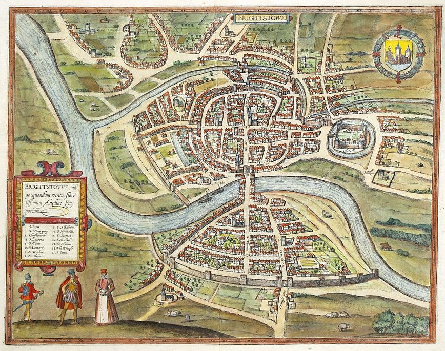
Brightstowe, vulgo quondam venta, floretissimum Angliae Emporium.

BRAUN, Georg & HOGENBERG, Franz.
Origin: Cologne, c.1582, Latin text edition.
Condition: Uncoloured; very minor nicks to edges of the margins, very light toning from an earlier mount, otherwise a fine example.
Size: 345 x 445mm (13½ x 17½ inches).
Reference: 10514
Price: £540
Brightstowe, vulgo, quondam venta florentissimum Angliae Emporium.
BRAUN, Georg & HOGENBERG, Franz.
Origin: Cologne, 1574-.
Condition: Coloured, possibly old ; some soiling and staining mainly to the margins, very short split to centrefold at lower margin (repaired), otherwise overall a very good example.
Size: 345 x 435mm (13½ x 17¼ inches).
Reference: 15704
Price: £630
Bristol.

DAWSON, Robert Kearsley.
Origin: London, 1832.
Condition: Original coloured lithograph; light age-toning to the edges of the paper, minor spotting, trimmed close on the left margin, with no loss of printed surface, otherwise a very good example.
Size: 320 x 205mm (12½ x 8 inches).
Reference: 11751
Price: £48
Civitas Exoniæ (vulgo Excester) Urbs Primaria in Comitatu Devoniæ.
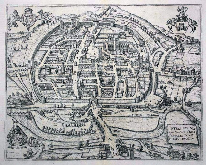
BRAUN, Georg & HOGENBERG, Franz.
Origin: Cologne, 1618, French text edition.
Condition: Uncoloured; very light age-toning to the edges of the margins, two small wormholes to the lower margin, overall a fine example.
Size: 320 x 410mm (12½ x 16¼ inches).
Reference: 12500
Price: £680
Civitas Exoniæ (vulgo Excester) Urbs Primaria in Comitatu Devoniæ.

BRAUN, Georg & HOGENBERG, Franz.
Origin: Cologne, 1617, Latin text edition.
Condition: Coloured; short tear to edge of lower margin, very light age-toning to the edges of the paper, overall a fine example.
Size: 320 x 405mm (12½ x 16 inches).
Reference: 15745
Price: £720
Comitatus Dorcestria sive Dorsettia vulgo Angliae Dorset Shire.

BLAEU, Johannes.
Origin: Amsterdam, 1658 , Dutch text edition.
Condition: Fine original colour; very light marginal soiling, two small worm holes in the lower margin, otherwise a superb example.
Size: 380 x 500mm (15 x 19¾ inches).
Reference: 10138
Price: £520
Comitatus Dorcestria sive Dorsettia vulgo Anglice Dorset Shire.

BLAEU, Joan.
Origin: Amsterdam, 1654.
Condition: Fine original colour; light marginal soiling, two small marginal printers creases, two small worm holes again in the margins, the top one just clipping the printed line border, otherwise a fine example.
Size: 380 x 500mm (15 x 19¾ inches).
Reference: 9033
Price: £420
Cornubia, sive Cornwallia.

BLAEU, Johannes.
Origin: Amsterdam, 1662, French text edition.
Condition: Original colour; light offsetting of colour (blue) from armorial, minor waterstaining and age-toning to the edges of the paper, otherwise a very good example.
Size: 395 x 500mm (15½ x 19¾ inches).
Reference: 11209
Price: £480
Cornwall.

CREIGHTON, R.
Origin: London, 1842.
Condition: Original outline colour; fine condition.
Size: 185 x 225mm (7¼ x 8¾ inches).
Reference: 12503
Price: £23
Cornwall.

MOULE, Thomas.
Origin: London c.1837.
Condition: Uncoloured; light soiling and age-toning to the margins, otherwise a good example.
Size: 205 x 260mm (8 x 10¼ inches).
Reference: 12538
Price: £48
Cornwall.

BICKHAM, George.
Origin: London, Laurie and Whittle, 1754-96.
Condition: Coloured; quite heavily stained and toned particularly to the margins, probably caused by the acidity in the mount of a previous framing, overall presentable.
Size: 234 x 142mm (9¼ x 5½ inches).
Reference: 16117
Price: £280
Dartmouth.

DAWSON, Robert Kearsley.
Origin: London, 1832.
Condition: Original coloured lithograph; light age-toning to the edges of the paper, minor spotting, light print offset, vertical fold from book, otherwise a very good example.
Size: 320 x 270mm (12½ x 10¾ inches).
Reference: 11904
Price: £38
Devon Shire.

BOWEN, Emanuel.
Origin: London, c.1720.
Condition: Uncoloured; light age-toning and minor nicks to margins, otherwise fine condition.
Size: 120 x 120mm (4¾ x 4¾ inches).
Reference: 12607
Price: £38
Devoniæ comitatus vulgo den:shyre quam olim Danmonii populi incoluerunt.
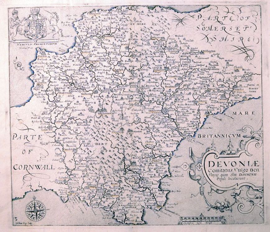
Kip, William.
Origin: London, 1607-37.
Condition: Uncoloured; some place names underlined in faint brown ink, otherwise a very good example.
Size: 295 x 335mm (11½ x 13¼ inches).
Reference: 7746
Price: £280
Devonia vulgo Devon-Shire.

BLAEU, Joan.
Origin: Amsterdam, 1654.
Condition: Fine original colour; light marginal soiling, small rust stain in left margin, two small wotm holes in upper margin, otherwise a fine example.
Size: 390 x 500mm (15¼ x 19¾ inches).
Reference: 9029
Price: £540
Dorchester.

DAWSON, Robert Kearsley.
Origin: London, 1832.
Condition: Original coloured lithograph; light age-toning to the edges of the paper, minor spotting, otherwise a good example.
Size: 280 x 190mm (11 x 7½ inches).
Reference: 12334
Price: £25
Dorset Shire.

OWEN, J. & BOWEN, E.
Origin: London, c.1720.
Condition: Uncoloured; split in the margin caused by the pressure of the printing plate, visible when held up to the light, age-toning to the edges, otherwise a very good example.
Size: 185 x 120mm (7¼ x 4¾ inches).
Reference: 10393
Price: £38
Dorsetshyre With the Shyre towne Dorcester described, as also the Armes of such noble families as have bene honored with the Titles there of since the Normans Conquest to this present Anno. 1610.

SPEED, John.
Origin: London, John Sudbury & George Humble, 1610-27.
Condition: Coloured; light soiling and toning to the margins, minor expert repairs to lower centrefold, some old ink manuscript in the Devon area of the map (hardly noticeable), otherwise a very good example.
Size: 380 x 505mm (15 x 20 inches).
Reference: 9485
Price: £690
Dorsetshyre With the Shyre towne Dorcester described, as also the Armes of such noble families as have bene honored with the Titles there of since the Normans Conquest to this present Anno. 1610.

SPEED, John.
Origin: London, John Sudbury & George Humble, 1610-12, FIRST EDITION.
Condition: Uncoloured; two small holes (now repaired with old paper, one each in the upper and lower margins at centrefold, probably used as a guide for the binder to fold, slight toning at centrefold, otherwise a fine dark impression.
Size: 385 x 515mm (15¼ x 20¼ inches).
Reference: 11522
Price: £1050
Dorsetshyre With the Shyre towne Dorcester described, as also the Armes of such noble families as have bene honored with the Titles there of since the Normans Conquest to this present Anno.1610.

SPEED, John.
Origin: London, John Sudbury & George Humble, 1610-16, Latin text edition.
Condition: Colour; slight age-toning of the paper, a couple of small holes (paper faults) visible when held up to the light, small nicks to the edges of the paper, minor discolouration and soiling, otherwise a good example.
Size: 385 x 515mm (15¼ x 20¼ inches).
Reference: 15625
Price: £680
Exeter.

DAWSON, Robert Kearsley.
Origin: London, 1832.
Condition: Original coloured lithograph; light age-toning to the edges of the paper, minor spotting, some soiling on old vertical fold from book, otherwise a good example.
Size: 325 x 180mm (12¾ x 7 inches).
Reference: 12360
Price: £38
Glastonbury.

DAWSON, Robert Kearsley.
Origin: London, 1832.
Condition: Original coloured lithograph; light age-toning to the edges of the paper, minor spotting, old vertical fold from volume with light soiling, otherwise a very good example.
Size: 310 x 250mm (12¼ x 9¾ inches).
Reference: 12109
Price: £28
Helstone.

DAWSON, Robert Kearsley.
Origin: London, 1832.
Condition: Original coloured lithograph; light age-toning to the edges of the paper, some light spotting and minor foxing, otherwise a good example.
Size: 300 x 190mm (11¾ x 7½ inches).
Reference: 12036
Price: £24
Launceston.

DAWSON, Robert Kearsley.
Origin: London, 1832.
Condition: Original coloured lithograph; light age-toning to the edges of the paper, minor spotting, otherwise a good example.
Size: 325 x 180mm (12¾ x 7 inches).
Reference: 12361
Price: £25
Liskeard.

DAWSON, Robert Kearsley.
Origin: London, 1832.
Condition: Original coloured lithograph; light age-toning to the edges of the paper, some light spotting and minor foxing, signs of old vertical folds from book, otherwise a very good example.
Size: 310 x 240mm (12¼ x 9½ inches).
Reference: 12024
Price: £25
Penryn.

DAWSON, Robert Kearsley.
Origin: London, 1832.
Condition: Original coloured lithograph; light age-toning to the edges of the paper, minor spotting, otherwise a very good example.
Size: 285 x 180mm (11¼ x 7 inches).
Reference: 11764
Price: £25
Penzance.

DAWSON, Robert Kearsley.
Origin: London, 1832.
Condition: Original coloured lithograph; light age-toning to the edges of the paper, minor spotting, otherwise a fine example.
Size: 305 x 200mm (12 x 7¾ inches).
Reference: 11724
Price: £45
Plymouth, Devonport and Stonehouse.

TALLIS, John.
Origin: London, John Tallis & Co., 1851.
Condition: unknown
Size: 260 x 345mm (10¼ x 13½ inches).
Reference: 12552
Price: £130
Plymouth.

DAWSON, Robert Kearsley.
Origin: London, 1832.
Condition: Original coloured lithograph; light age-toning to the edges of the paper, minor spotting, signs of vertical fold from volume, minor print offset, otherwise a very good example.
Size: 270 x 300mm (10¾ x 11¾ inches).
Reference: 11725
Price: £48
Poole.

DAWSON, Robert Kearsley.
Origin: London, 1832.
Condition: Original coloured lithograph; light age-toning to the edges of the paper, minor spotting, otherwise a very good example.
Size: 320 x 200mm (12½ x 7¾ inches).
Reference: 11727
Price: £48
Shaftesbury.
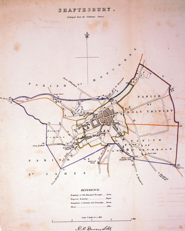
DAWSON, Robert Kearsley.
Origin: London, 1832.
Condition: Original coloured lithograph; light age-toning to the edges of the paper, some minor spotting, otherwise a good example.
Size: 290 x 240mm (11½ x 9½ inches).
Reference: 11798
Price: £38
Somerset_Shire Desribed ãd into Hundreds devided, with the plott of the famous and most wholsom waters and citie of the Bathe.

SPEED, John.
Origin: London, John Sudbury & George Humble, 1610-11. FIRST EDITION.
Condition: Uncoloured; two pin holes to the upper and lower margin just outside the printed surface in the centrefold (possibly as a guide for the binder), minor marginal soiling, light centrefold toning, otherwise a fine dark impression.
Size: 380 x 510mm (15 x 20 inches).
Reference: 10723
Price: £1150
Somersettensis Comitatus. Somerset Shire.

BLAEU, Johannes.
Origin: Amsterdam, 1648, Dutch text edition.
Condition: Superb original colour; minor age-toning to the edges of the margins, overall a fine example.
Size: 385 x 495mm (15¼ x 19½ inches).
Reference: 11642
Price: £430
St. Ives.

DAWSON, Robert Kearsley.
Origin: London, 1832.
Condition: Original coloured lithograph; light age-toning to the edges of the paper, minor spotting and surface soiling, otherwise a good example.
Size: 315 x 170mm (12½ x 6¾ inches).
Reference: 12368
Price: £28
The Continuation of the Road from London to the Lands-End. Plate 2d.

OGILBY, John.
Origin: London, 1675.
Condition: Uncoloured; light age-toning to the edges of the paper, light creases, otherwise a good example.
Size: 320 x 435mm (12½ x 17¼ inches).
Reference: 12989
Price: £120
The Lizard and Adjacent Rocks. Surveyed by Capt. G.Williams and Mr J.S.Wells Master. 1851.

POTTER, J.D.
Origin: London, J.D.Potter, for the Admiralty, 1856.
Condition: Coloured; some short tears to folds, mounting tape from old frame on verso, light age-toning from mount, minor spotting, otherwise a very good example.
Size: 500 x 615mm (19¾ x 24¼ inches).
Reference: 11167
Price: £240
The Road from Bristol to Weymouth com. Dorset.

OGILBY, John.
Origin: London, 1675.
Condition: Coloured; very light marginal age-toning, minor marginal nicks, light creasing to paper, overall a good example.
Size: 340 x 435mm (13½ x 17¼ inches).
Reference: 12943
Price: £160
The Road from Bristol to Weymouth com. Dorset.

OGILBY, John.
Origin: London, 1675-.
Condition: Coloured; very light marginal age-toning, minor marginal nicks, overall a good example.
Size: 340 x 435mm (13½ x 17¼ inches).
Reference: 12968
Price: £160
The Road from London to Weymouth com. Dorset.

OGILBY, John.
Origin: London, 1675-.
Condition: Uncoloured; very light age-toning to the edges of the paper, otherwise a fine example.
Size: 345 x 475mm (13½ x 18¾ inches).
Reference: 12969
Price: £130
Tiverton.

DAWSON, Robert Kearsley.
Origin: London, 1832.
Condition: Original coloured lithograph; light age-toning to the edges of the paper, some light spotting and minor foxing, otherwise a good example.
Size: 325 x 260mm (12¾ x 10¼ inches).
Reference: 12031
Price: £28
Torrington.

DAWSON, Robert Kearsley.
Origin: London, 1832.
Condition: Original coloured lithograph; light age-toning to the edges of the paper, some light spotting and minor foxing, otherwise a good example.
Size: 280 x 200mm (11 x 7¾ inches).
Reference: 12034
Price: £24
Totnes.

DAWSON, Robert Kearsley.
Origin: London, 1832.
Condition: Original coloured lithograph; light age-toning to the edges of the paper, some minor spotting, trimmed close on left hand side due to binding, sign of old vertical fold from book, otherwise a good example.
Size: 310 x 210mm (12¼ x 8¼ inches).
Reference: 11799
Price: £35
Truro.

DAWSON, Robert Kearsley.
Origin: London, 1832.
Condition: Original coloured lithograph; light age-toning to the edges of the paper, minor spotting, otherwise a very good example.
Size: 310 x 190mm (12¼ x 7½ inches).
Reference: 11920
Price: £42
Wells.

DAWSON, Robert Kearsley.
Origin: London, 1832.
Condition: Original coloured lithograph; light age-toning to the edges of the paper, minor spotting, otherwise a good example.
Size: 295 x 180mm (11½ x 7 inches).
Reference: 12337
Price: £24
Weymouth.

DAWSON, Robert Kearsley.
Origin: London, 1832.
Condition: Original coloured lithograph; light age-toning to the edges of the paper, minor spotting, otherwise a very good example.
Size: 315 x 190mm (12½ x 7½ inches).
Reference: 11733
Price: £45
