Antique Maps of Eastern Europe
A Map of Russia.
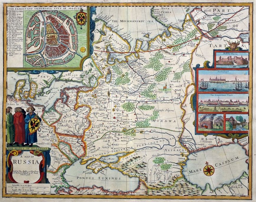
SPEED, John.
Origin: London, Bassett & Chiswell, 1676.
Condition: Coloured; some expert repairs to shorts splits at the edges of the paper, other minor paper fault repairs, visible when held up to the light, otherwise overall a good example.
Size: 400 x 505mm (15¾ x 20 inches).
Reference: 15609
Price: £2150
A Map of Russia.

SPEED, John.
Origin: London, Bassett & Chiswell, 1676.
Condition: Coloured; some expert repairs to the centrefold in the lower margin and a small repaired hole in the Murmansk Sea (visible when held up to the light), trimmed close by binder at the top edge with no loss of printed line border, otherwise overall a very good example.
Size: 400 x 505mm (15¾ x 20 inches).
Reference: 15641
Price: £2250
Bataille de Praag en Bohéme, gragnée par le Roi de Prusse, sur l'Armée des Impériaux, commandée par le Prince Charles de Lorraine, le 6 May, 1757.

ANON.
Origin: [Paris, c.1760].
Condition: Some original colour; waterstained, light soiling, otherwise good.
Size: 360 x 520mm (14¼ x 20½ inches).
Reference: 12282
Price: £98
Combat de Lowositz, en Bohéme, gagné par le Roi de Prusse sur l'Armée Impériale aux or dres du Feldmaréchal de Brown, le 1er Octobre, 1756.

ANON.
Origin: [Paris, c.1760].
Condition: Some orignal colour; waterstained and age-toned, some surface soiling, otherwise presentable.
Size: 355 x 510mm (14 x 20 inches).
Reference: 12285
Price: £95
Combat de Reichenberg en Bohéme, Gagne par le Prince de Bevern, Lieutenant-General commandant un Corps de Troupes Prussiennes, sur un autre des Impériaux, conduit par le Feldzeugmeisetr Conte de Koenigsegg, le 21 Avril 1757.

ANON.
Origin: [Paris, c.1760].
Condition: Some original colour; light waterstaining, minor soiling, otherwise a good example.
Size: 355 x 510mm (14 x 20 inches).
Reference: 12284
Price: £80
Constantinople. Stambool.

Society for the Diffusion of Useful Knowledge. (S.D.U.K.)
Origin: London, Baldwin & Cradock, 1840.
Condition: Original outline colour; light age-toning to the edges of the margins, very light print offset, otherwise a very good example.
Size: 325 x 395mm (12¾ x 15½ inches).
Reference: 10646
Price: £75
Delineatio Freti Vaigats.

BERTIUS, Petrus.
Origin: Amsterdam, Judocus Hondius, 1616.
Condition: Uncoloured; very light overall age-toning and minor marginal staining, otherwise fine condition.
Size: 100 x 140mm (4 x 5½ inches).
Reference: 9945
Price: £58
Detroit de Waigats.

MALLET, Alain Manesson.
Origin: Paris, 1683. French text edition.
Condition: Uncoloured; light age-toning, otherwise a very good example.
Size: 150 x 105mm (6 x 4¼ inches).
Reference: 11672
Price: £48
Hungary.

TALLIS, John.
Origin: London, John Tallis & Co., 1851.
Condition: Original outline colour; good to fine condition.
Size: 260 x 350mm (10¼ x 13¾ inches).
Reference: 7788
Price: £42
Moscow.

Society for the Diffusion of Useful Knowledge, (S.D.U.K.)
Origin: London, Baldwin & Cradock, 1836.
Condition: Original outline colour; light age-toning to the edges of the margins, otherwise a very good example.
Size: 335 x 360mm (13¼ x 14¼ inches).
Reference: 10664
Price: £190
Natolia quae olim Asia Minor.

BLAEU, Johannes.
Origin: Amsterdam, 1640, French text edition.
Condition: Original colour; very light soiling in the margins, with some contemporary ink manuscript well away from the printed area, short repaired centrefold split, again well away from the printed surface, generally a fine example.
Size: 390 x 505mm (15¼ x 20 inches).
Reference: 15514
Price: £320
Nouvelle Zemble.

MALLET, Alain Manesson.
Origin: Paris, 1683. French text edition.
Condition: Uncoloured; light age-toning, otherwise a very good example.
Size: 150 x 105mm (6 x 4¼ inches).
Reference: 11673
Price: £65
Novæ Zemlæ delineatio.

BERTIUS, Petrus.
Origin: Amsterdam, Judocus Hondius, 1616.
Condition: Uncoloured; very light overall age-toning and minor marginal staining, otherwise fine condition.
Size: 95 x 135mm (3¾ x 5¼ inches).
Reference: 9099
Price: £65
Prussia.

TALLIS, John.
Origin: London, John Tallis & Co., 1851.
Condition: Original outline colour; cut close at top edge just clipping the Prussian Eagle, otherwise very good.
Size: 265 x 330mm (10½ x 13 inches).
Reference: 7771
Price: £38
Russia in Asia.

TALLIS, John.
Origin: London, John Tallis & Co. 1851.
Condition: Original outline colour; minor marginal spotting, otherwise fine.
Size: 260 x 325mm (10¼ x 12¾ inches).
Reference: 7449
Price: £38
Russia in Europe.

TALLIS, John.
Origin: London, J & F Tallis, 1851.
Condition: Original outline colour; minor marginal spotting, otherwise fine.
Size: 350 x 245mm (13¾ x 9¾ inches).
Reference: 7448
Price: £85
Süd - Russland und Kaukasien.

SCHLACHER, J.
Origin: Vienna, 1886.
Condition: Original coloured lithograph; some waterstaining, light surface soiling and spotting, otherwise a good example.
Size: 355 x 495mm (14 x 19½ inches).
Reference: 12286
Price: £48
St. Petersburg.

S.D.U.K.
Origin: London, Baldwin & Cradock, 1834.
Condition: Original outline colour; light age-toning to the edges of the paper, otherwise a fine example.
Size: 330 x 388mm (13 x 15¼ inches).
Reference: 16110
Price: £180
Tab.I.Asiæ, in qua Galatia, Cappadocia. Pontus, Bithynia, Asia Minor, Pamphylia, Lycia, ac Cilicia...

PTOLEMY, Claudius - MERCATOR, Gerard.
Origin: [Amsterdam, c.1695.].
Condition: Uncoloured; very light soiling in the lower margin, light age-toning, otherwise overall a fine example.
Size: 350 x 465mm (13¾ x 18¼ inches).
Reference: 15516
Price: £180
Turkey in Europe.

TALLIS, John.
Origin: London, John Tallis & Co., 1851.
Condition: Original outline colour; trimmed to upper margin with minor loss of scrolling on title.
Size: 260 x 330mm (10¼ x 13 inches).
Reference: 6867
Price: £28
Warsaw.

S.D.U.K.
Origin: London, Baldwin & Cradock, 1831.
Condition: Original outline colour; light age-toning to the edges of the margins, one or two light spots, otherwise overall a fine example.
Size: 310 x 378mm (12¼ x 15 inches).
Reference: 16114
Price: £150
