Antique Maps of Southern Africa
South Africa, Congo, Guinea, Ethiopia, Central Africa

Cape Colony.

image

TALLIS, John.

Origin: London, John Tallis & Company, 1851.

With engraved vignettes including a view of Cape Town. John Tallis is without question one of the most renowned cartographers and publisher of the C19th. His maps are the last of the lavishly decorated and ornamental maps, considered to be works of art as well as geographically accurate. He was born in Stourbridge in Worcestershire in about 1818 and it is likely that he stayed in the Midlands working as a publisher in Birmingham, until he moved to London in the early 1840′s.

Condition: Original outline colour; very minor marginal age-toning, otherwise a fine example.

Size: 255 x 325mm (10 x 12¾ inches).

Reference: 7480

Price: £110

[this is simply us checking that you are a human!]

Carta Geografica del Capo di Buona Speranza.

image

L'ISLE, Guillaume de..

Origin: Venice, Girolamo Albrizzi, 1740.

A detailed map of the Cape of Good Hope from 'Atlante Novissimo che Contiene Tutte le Parti del Mondo'. Decorative cartouche shows an elephant and two species of rhinosaurus.

Condition: Uncoloured; light centrefold toning due to guard paste, very light print offset and minor marginal staining, otherwise a fine example.

Size: 335 x 430mm (13¼ x 17 inches).

Reference: 9773

Price: £340

[this is simply us checking that you are a human!]

Carte de la Baye de Sainte Helene...

image

BELLIN, Jacques Nicholas.

Origin: Paris, 1764-.

A small chart of the coast and inlet of St Helena Bay on the Atlantic coast of Africa north of Capetown. Jaques Nicolas Bellin (1702-720) was the most important French hydrographer of the 18th century. St Helena Bay was "discovered" by the Portuguese explorer Vasco Da Gama on 7 Nov. 1497, during his pioneer voyage from Europe to India. He named the bay after Saint Helena, a devout, influential Christian and mother of Roman Emperor Constantine the Great.

Condition: Uncoloured; overall fine condition.

Size: 210 x 160mm (8¼ x 6¼ inches).

Reference: 15460

Price: £68

[this is simply us checking that you are a human!]

Carte du Royaume de Congo, du Monomotapa et de la Cafrerie.

image

CHATELAIN, Henri Abraham.

Origin: Amsterdam, c.1719.

A fine detailed map of Southern Africa.

Condition: Uncoloured; dark impression, very minor marginal staining otherwise fine condition.

Size: 405 x 520mm (16 x 20½ inches).

Reference: 8388

Price: £340

[this is simply us checking that you are a human!]

Congo, Cafrerie.

image

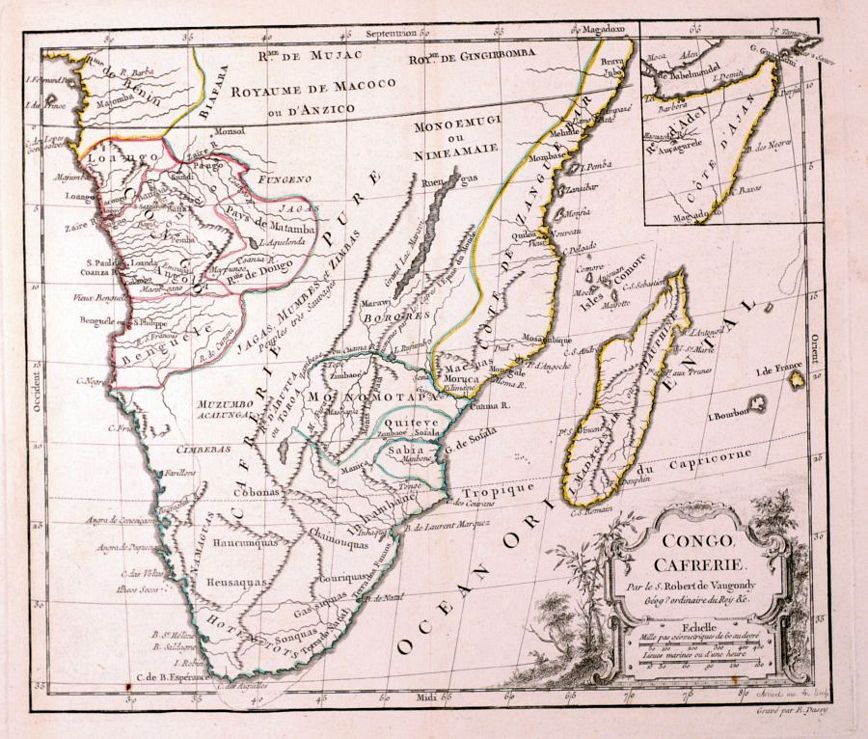
VAUGONDY, G. Robert de.

Origin: Paris, C.F. Delamarche, 1806.

Southern Africa, with an inset of the Horn of Africa.

Condition: Original outline colour; light toning to the margins, overall a good example.

Size: 245 x 280mm (9¾ x 11 inches).

Reference: 2414

Price: £110

[this is simply us checking that you are a human!]

D'Eilanden van Capo Verde. De kust en't Landt der Negeren.

image

SANSON, Nicholas.

Origin: Paris, 1656-1705.

A map of West Africa and the Cape Verde Islands engraved by A de Winter and published in the Dutch edition of the small atlas by Nicholas Sanson.

Condition: Uncoloured; light marginal age-toning and one minor nick well away from platemark, otherwise fine condition.

Size: 200 x 285mm (7¾ x 11¼ inches).

Reference: 9115

Price: £85

[this is simply us checking that you are a human!]

Guinea.

image

JANSSON, Joannes.

Origin: Amsterdam, c.1630.

A map of Guinea, decorated with elephants, lions and monkeys. Highly detailed figured cartouche and ships adorn the sea area.

Condition: Fine orignial colour; very light age-toning and marginal spotting, expert repairs to centrefold (hardly visible), minor print offsetting, otherwise a very good example.

Size: 385 x 520mm (15¼ x 20½ inches).

Reference: 11163

Price: £430

[this is simply us checking that you are a human!]

La Guinea Occidentale che contiene le Isole di Capo Verde il Senegal la Costa Propriamente detta della Guinea.

image

ZATTA, Antonio.

Origin: Venice, 1784.

A map of Western Africa, covering the area now known as Senagal, Ivory Coast, Ghana, Liberia, Sierra Leone and of course Guinea. From 'Atlante Novissimo'.

Condition: Original colour; very light marginal staining, otherwise a fine example.

Size: 420 x 315mm (16½ x 12½ inches).

Reference: 8506

Price: £98

[this is simply us checking that you are a human!]

La Guinea Orientale che contiene li Regni di Loango, Congo, Angola e Benguela.

image

ZATTA, Antonio.

Origin: Venice, 1784.

A map of Western Africa, covering the area now known as Nigeria, Cameroon Gabon and Congo. From 'Atlante Novissimo'.

Condition: Original colour; very light marginal staining, otherwise a fine example.

Size: 405 x 310mm (16 x 12¼ inches).

Reference: 8505

Price: £140

[this is simply us checking that you are a human!]

Natal and Kaffraria.

image

TALLIS, John.

Origin: London, London Printing & Publishing Co., 1851.

With two vignettes; a view of Durban and Port Natal. John Tallis is without question one of the most renowned cartographers and publisher of the C19th. His maps are the last of the lavishly decorated and ornamental maps, considered to be works of art as well as geographically accurate. He was born in Stourbridge in Worcestershire in about 1818 and it is likely that he stayed in the Midlands working as a publisher in Birmingham, until he moved to London in the early 1840′s.

Condition: Original outline colour; very minor marginal soiling, otherwise fine example without centrefold..

Size: 360 x 250mm (14¼ x 9¾ inches).

Reference: 7552

Price: £75

[this is simply us checking that you are a human!]

Originalkarte des Westlichen Theiles des Oberen Nil-Gebietes...…
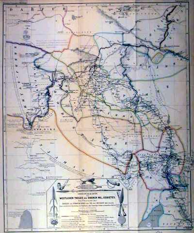
image

PETERMANN, A.

Origin: Gotha, 1865.

A contemporary German map showing the various routes of explorers to the interior of Africa, including; Pouncet, Petherick, Morlang, Binder, Speke and Grant, among others.

Condition: Original coloured lithograph; signs of old folds from book, light age-toning, otherwise a very good example.

Size: 525 x 430mm (20¾ x 17 inches).

Reference: 11473

Price: £32

[this is simply us checking that you are a human!]

Pays, et Coste des Caffres: Empires de Monomotapa Monoemugi &c.
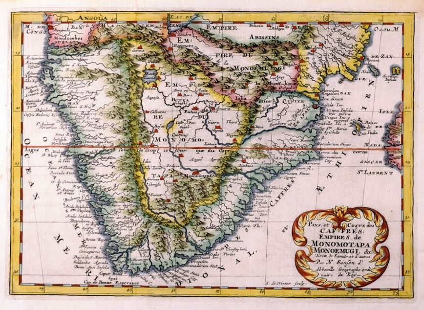
image

SANSON, Nicholas.

Origin: Paris, 1683.

A map of South Africa, with decorative floral cartouche. Engraved by Antoine de Winter.

Condition: Coloured; light age-toning to the margins, otherwise a fine example.

Size: 200 x 285mm (7¾ x 11¼ inches).

Reference: 13016

Price: £190

[this is simply us checking that you are a human!]

Western Africa.

image

TALLIS, John.

Origin: London, John Tallis & Company, 1851.

With engraved vignettes including a panorama of Sierra Leone. John Tallis is without question one of the most renowned cartographers and publisher of the C19th. His maps are the last of the lavishly decorated and ornamental maps, considered to be works of art as well as geographically accurate. He was born in Stourbridge in Worcestershire in about 1818 and it is likely that he stayed in the Midlands working as a publisher in Birmingham, until he moved to London in the early 1840′s.

Condition: Original outline colour; very light age-toning to margins, otherwise a fine example.

Size: 255 x 345mm (10 x 13½ inches).

Reference: 8222

Price: £42

[this is simply us checking that you are a human!]