Antique Maps of Ireland

Ancienne Isle D'Hibernie.

image

MALLET, Alain Manesson.

Origin: Paris, 1683, French text edition.

A miniature map of ancient Ireland. Showing the old divisions. From the French text edition of the five volume work 'Description de l'univers'.

Condition: Uncoloured; light marginal age-toning, otherwise a good example.

Size: 150 x 100mm (6 x 4 inches).

Reference: 12093

Price: £95

[this is simply us checking that you are a human!]

Dublin.

image

MALLET, Alain Manesson.

Origin: Paris, 1683. French text edition.

A delightful miniature plan of Dublin. From the 'Description de l'Univers", a five volume work.

Condition: Uncoloured; light soiling to margins, minor age-toning to the edges of the paper, small nick in the lower margin, well away from the printed area, otherwise a very good example.

Size: 160 x 105mm (6¼ x 4¼ inches).

Reference: 10796

Price: £90

[this is simply us checking that you are a human!]

Ireland.

image

TALLIS, John.

Origin: London, London Printing & Publishing Co., 1851.

With wonderfully engraved steel vignette views of Limerick and Ross Castles, and St Patrick's Dublin by J. Marchant and J. Rogers, (engraver).

Condition: Original outline colour; very minor soiling to the margins, otherwise a fine unfolded example.

Size: 350 x 235mm (13¾ x 9¼ inches).

Reference: 7472

Price: £210

[this is simply us checking that you are a human!]

Irlandiae Regnum.

image

MERCATOR, Gerard.

Origin: Amsterdam, Henry Hondius, 1628, French text edition.

Decorative map, orientated with north to the right, with the title on a banner above the map.

Condition: Coloured; light age-toning and minor marginal soiling, signs of old printers creases around the centrefold, short repaired tears to lower margin, otherwise a good example.

Size: 340 x 420mm (13½ x 16½ inches).

Reference: 12779

Price: £580

[this is simply us checking that you are a human!]

Isle D'Irlande.

image

MALLET, Alain Manesson.

Origin: Paris, 1683, French text edition.

A miniature map of Ireland.

Condition: Uncoloured; light age-toning to the margins, overall a good example.

Size: 155 x 100mm (6 x 4 inches).

Reference: 5897

Price: £90

[this is simply us checking that you are a human!]

Linster.

image

KEERE, Pieter van den.

Origin: London, George Humble, 1646.

A map of the Province of Leinster in Ireland from the so-called "Miniature Speed".

Condition: Uncoloured; light marginal soiling, otherwise very good.

Size: 85 x 120mm (3¼ x 4¾ inches).

Reference: 4744

Price: £65

[this is simply us checking that you are a human!]

Pratts High Test Plan of Ireland.

image

TAYLOR, Alfred. E.

Origin: [London], Pratts (publisher), 1930.

A pictorial map of Ireland, with decorative border. One of the decorative series of maps by artist Alfred Edward Taylor (1887-1959), which were published by Pratts, a petroleum company in the 1930's. This example being one of the coloured editions they issued. Features a decorative cartouche and compass, literary quotes and places of interest. "A.E. Taylor 33" printed at lower right corner.

Condition: Original colour printed; signs of old folds, small holes at the intersections of the folds (repaired with archivist tissue), overall a fine example.

Size: 660 x 455mm (26 x 18 inches).

Reference: 15667

Price: £380

[this is simply us checking that you are a human!]

Royaume D'Ireland.

image

MALLET, Alain Manesson.

Origin: Paris, 1683, French text edition.

A miniature map of Ireland. From the French text edition of the five volume work 'Description de l'Univers'.

Condition: Uncoloured; light marginal soiling and light age toning, otherwise a good example.

Size: 160 x 115mm (6¼ x 4½ inches).

Reference: 11670

Price: £90

[this is simply us checking that you are a human!]

Royaume D'Ireland.

image

MALLET, Alain Manesson.

Origin: Paris, 1683, French text edition.

A miniature map of Ireland. From the French text edition of the five volume work 'Description de l'Univers'.

Condition: Uncoloured; light marginal soiling and light age toning, otherwise a good example.

Size: 160 x 115mm (6¼ x 4½ inches).

Reference: 12610

Price: £85

[this is simply us checking that you are a human!]

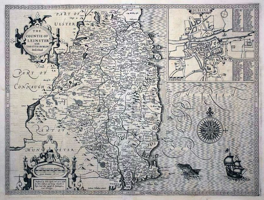
The Countie of Leinster with the Citie Dublin Described.

image

SPEED, John.

Origin: London, Sudbury & Humble, 1610-16, Latin text edition.

From the Latin edition of Speed's 'Theatre of the Empire of Great Britaine', published to exploit the continental market. Engraved by Jodocus Hondius in 1610, the map has an inset plan of Dublin with a 69-point key, and finely engraved compass rose, galleon and sea-monster.

Condition: Uncoloured; very light soiling to the edges of the margins, overall a fine example.

Size: 380 x 505mm (15 x 20 inches).

Reference: 15389

Price: £1150

[this is simply us checking that you are a human!]

The Countie of Leinster with The Citie Dublin Described.

image

SPEED, John.

Origin: London, John Sudbury & George Humble 1610-12. FIRST EDITION.

From Speed's 'Theatre of the Empire of Great Britaine', engraved by Jodocus Hondius in Amsterdam 1610, the map has an inset plan of Dublin with a 69-point key, and finely engraved compass rose, galleon and sea-monster.

Condition: Uncoloured; dark impression with only minor marginal nicks and light soiling, short repaired centrefold split, two pin holes in the centrefold just outside the printed surface, possibly as a guide to the binder, otherwise a fine example.

Size: 385 x 510mm (15¼ x 20 inches).

Reference: 11118

Price: £1150

[this is simply us checking that you are a human!]

The Environs of Dublin.

image

Society for the Diffusion of Useful Knowledge, (S.D.U.K.)

Origin: London, Baldwin & Cradock, 1837.

An early Victorian map of Dublin and the environs, drawn and engraved by B.R.Davies. From the 1844 edition published by Chapman & Hall, for The Society for the Diffusion of Useful Knowledge.

Condition: Original outline colour; light age-toning to the edges of the margins, light soiling, otherwise a very good example.

Size: 335 x 400mm (13¼ x 15¾ inches).

Reference: 10647

Price: £28

[this is simply us checking that you are a human!]

The Environs of Dublin.

image

Society for the Diffusion of Useful Knowledge, (S.D.U.K.)

Origin: London, Thomas Letts, [1877].

A Victorian map of Dublin and the environs, drawn and engraved by B.R.Davies. From the 1877 edition published by Thomas Letts for The Society for the Diffusion of Useful Knowledge.

Condition: Original outline colour; very light age-toning to the edges of the margins, otherwise a fine example.

Size: 335 x 400mm (13¼ x 15¾ inches).

Reference: 10685

Price: £36

[this is simply us checking that you are a human!]

The Province of Mounster.

image

SPEED, John.

Origin: London, John Sudbury & George Humble 1610-16, Latin text on verso.

Fine map of the province of Mounster, from Speed's 'Theatre of the Empire of Great Britaine', engraved by Jodocus Hondius in Amsterdam 1610, inset plan of Cork.

Condition: Uncoloured; dark impression, two pin holes in the centrefold just outside the printed surface, possibly as a guide to the binder, two small pin holes in the upper margin, trimmed close at the bottom edge with no loss and enough blank paper to facilitate framing, otherwise a fine example.

Size: 390 x 510mm (15¼ x 20 inches).

Reference: 11120

Price: £930

[this is simply us checking that you are a human!]

The Province of Mounster.

image

SPEED, John.

Origin: London, John Sudbury & George Humble 1610-46.

Fine map of the province of Mounster, from Speed's 'Theatre of the Empire of Great Britaine', engraved by Jodocus Hondius in Amsterdam 1610, inset plan of Cork.

Condition: Coloured; trimmed at top margin with loss of some of header only on verso, top margin has enough blank paper to facilitate framing, very minor restoration to centrefold, overall a very good example.

Size: 390 x 510mm (15¼ x 20 inches).

Reference: 12783

Price: £680

[this is simply us checking that you are a human!]

The Province of Ulster described.

image

SPEED, John.

Origin: London, John Sudbury & George Humble 1610-27.

The Province of Ulster with inset of Enniskillen in Fermanagh, printed by John Dawson, the text on the verso has been completely re-set from the earlier editions.

Condition: Uncoloured; very minor marginal nicks, light soiling and staining to the margins, otherwise overall a good example.

Size: 375 x 505mm (14¾ x 20 inches).

Reference: 12854

Price: £950

[this is simply us checking that you are a human!]

Udrone Irlandiæ in Caterlag Baronia.

image

MERCATOR, Gerard.

Origin: Amsterdam, 1636-, French text edition.

A map of Udrone, depicting present day County Carlow in Leinster Province and Catherlaugh which is now Carlow. The title cartouche (post 1636), has been changed from the earlier editions and is now surrounded by garlands of fruit topped with dividers & a mileage scale. Signed lower right hand corner Per Gerardum Mercatorem Cum Privilegio.

Condition: Original colour; lightly age-toned and slight fading of original colour, trimmed by framer some years ago with loss of some text on verso, but the map is left with good margins all round, short split to lower margin at centrefold, otherwise a good example.

Size: 345 x 280mm (13½ x 11 inches).

Reference: 12292

Price: £195

[this is simply us checking that you are a human!]

[No title].

image

DURY, Andrew.

Origin: London, 1764.

A miniature map of Ulster. Published by Dury in 'A Collection of Plans of the Principal Cities of Great Britain and Ireland: with Maps of the Coast of the said Kingdoms;'. Possibly engraved by J Cheevers.

Condition: Original colour; light soiling mainly to margins, otherwise fine condition.

Size: 120 x 95mm (4¾ x 3¾ inches).

Reference: 9594

Price: £60

[this is simply us checking that you are a human!]

[No title].

image

DURY, Andrew.

Origin: London, 1764.

A miniature map of Connaught. Published by Dury in 'A Collection of Plans of the Principal Cities of Great Britain and Ireland: with Maps of the Coast of the said Kingdoms;'. Possibly engraved by J Cheevers.

Condition: Original colour; light soiling mainly to margins, otherwise fine condition.

Size: 120 x 95mm (4¾ x 3¾ inches).

Reference: 9595

Price: £48

[this is simply us checking that you are a human!]

[No title].

image

DURY, Andrew.

Origin: London, 1764.

A miniature map of Leinster. Published by Dury in 'A Collection of Plans of the Principal Cities of Great Britain and Ireland: with Maps of the Coast of the said Kingdoms;'. Possibly engraved by J Cheevers.

Condition: Original colour; light soiling mainly to margins, otherwise fine condition.

Size: 120 x 95mm (4¾ x 3¾ inches).

Reference: 9596

Price: £65

[this is simply us checking that you are a human!]